


|
||

|

|
|

|
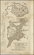
Nice example of the rare first edition of Faden's important Revolutionary War battle plan of Bunker Hill, based upon a manuscript map drawn by Lieutenant Thomas Hyde Page and Captain (later Major) John Montresor at the scene of the Battle in 1775.
This example includes the printed overflap at the center right of the map, which illustrates the progess of the Battle on Day 1 (flap) and Day 2 (area under the flap). The map is Faden's first Revolutionary War Battle Plan and the second large format printed battle plan of Bunker Hill, preceded only by Sayer & Bennett's much cruder and less detailed plan of the battle: /gallery/detail/33337mb
Faden's plan of Bunker Hill captures the action in and around the American Fortifications at Breed's Hill and Bunker Hill, in what would become the most famous of all early battles of the American Revolution. Washington had boldly fortified the area under the nose of the British in the days prior to the battle and worked all night to establish strong fortifications the night before the battle. Also shown are the tracks of two of the Royal Navy warships (HMS Lively and HMS Falcon) involved in the bombardment of Charlestown and the American fortifications and the direction of their cannon fire.
Thomas Hyde Page, an English military engineer who served as aide de campe to General Howe during the action, prepared this detailed plan of the Battle of Bunker Hill, with the assistance of John Montressor, one of the most famous of the English mapmakers working in America at the time. Warren's redoubt, fences, and hedgerows are shown in great detail, as well as the lines of march of attacking forces, British ships, and the Corps Hill battery with lines of fire.
The Battle of Bunker Hill, fought in Charlestown on June 17, 1775, was the first significant conflict of the Revolution, following the initial hostilities at Lexington and Concord. If those first encounters furnished the colonists with impetus to mobilize against Great Britain, Bunker Hill rallied them and demonstrated to the British government that they faced a determined foe. It took the astonished British almost a year before they resumed the offensive against the rebelling colonists.
The battle occurred after the Americans fortified Breed's Hill on the Charlestown Peninsula, which was frequently confused with Bunker Hill just to the northwest. This gave them command of much of the Inner Harbor, the entrance to the Charles, and part of the city itself. Confident in their superiority, the British ferried troops across the Charles and attacked the American emplacement head on. The battle was horrific for both sides, and the British were stunned by the ferocity of the Americans' defense and suffered more casualties than in any other encounter of the war.
Approximately 2,100 British troops under the command of General Thomas Gage stormed Breed's Hill, where colonial soldiers were encamped. In their fourth charge up the hillside, the British took the hill from the rebels, who had run out of ammunition. After suffering more than 1,000 casualties during their attacks on Breed's Hill, the British halted their assaults on rebel strongholds in Boston. The last rebels left on the hill evaded capture by the British thanks to the heroic efforts of Peter Salem, an African-American soldier who mortally wounded the British commanding officer who led the last charge. Following the battle, the siege of Boston settled into a stalemate until March 1776, with the British force confined to the town and the Americans unwilling to risk an attack.
The map example of the plan includes a unique extra flap which overlays a portion of the map and captures the details of the battle in two phases. The extra flap is frequently missing, making this example particularly desirable.
William Faden (1749-1836) was the most prominent London mapmaker and publisher of the late-eighteenth and early-nineteenth centuries. His father, William Mackfaden, was a printer who dropped the first part of his last name due to the Jacobite rising of 1745.
Apprenticed to an engraver in the Clothworkers' Company, he was made free of the Company in August of 1771. He entered into a partnership with the family of Thomas Jeffreys, a prolific and well-respected mapmaker who had recently died in 1771. This partnership lasted until 1776.
Also in 1776, Faden joined the Society of Civil Engineers, which later changed its name to the Smeatonian Society of Civil Engineers. The Smeatonians operated as an elite, yet practical, dining club and his membership led Faden to several engineering publications, including canal plans and plans of other new engineering projects.
Faden's star rose during the American Revolution, when he produced popular maps and atlases focused on the American colonies and the battles that raged within them. In 1783, just as the war ended, Faden inherited his father's estate, allowing him to fully control his business and expand it; in the same year he gained the title "Geographer in Ordinary to his Majesty."
Faden also commanded a large stock of British county maps, which made him attractive as a partner to the Ordnance Survey; he published the first Ordnance map in 1801, a map of Kent. The Admiralty also admired his work and acquired some of his plates which were re-issued as official naval charts.
Faden was renowned for his ingenuity as well as his business acumen. In 1796 he was awarded a gold medal by the Society of Arts. With his brother-in-law, the astronomer and painter John Russell, he created the first extant lunar globe.
After retiring in 1823 the lucrative business passed to James Wyld, a former apprentice. He died in Shepperton in 1826, leaving a large estate.
![(Coast of Florida, Georgia and the Carolinas] [To The Members Of The Nautical Institution And Ship-Masters' Society Of The City Of New York, This Chart, Extending From Lat. 40°15 N., Long. 72°15 W., to Lat. 22°35 N., Long. 80°25 W., Is Respectfully Dedicated / By Their Obedient Servant Edmund M. Blunt]](https://storage.googleapis.com/raremaps/img/small/77294.jpg)
![[ Large Cape Cod Inset ] The River & Gulf of St. Lawrence, Newfoundland, Nova Scotia, and The Banks Adjacent, From The English Admiralty & French Marine Surveys. . . . 1844. Additions To 1857.](https://storage.googleapis.com/raremaps/img/small/85637.jpg)
![[ The Finest Colonial New England Sea Chart of the 18th Century ] The Coast of New England](https://storage.googleapis.com/raremaps/img/small/63672.jpg)