


|
||

|

|
|

|
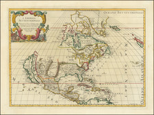
Second edition of Rossi's map of North America, based upon Sanson's seminal map, but with revised Italian nomenclature, from Rossi's Mercurio Geographico….
Rossi's map is based upon Sanson's map of North America, first issued in 1650. Rossi depicts California as an Island on the Sanson-Foxe model. The first two editions (1677 and 1687), show the Great Lakes with open ends at the western part of the Lakes, consistent with Sanso's mpdel. In approximately 1715, the map was modified significantly, although the date is unchanged (1687).
In the first two editions, the Rio del Norte (Rio Grande) is shown flowing into the Gulf of California, with Taos and Santa Fe in the North and identifying Cibola. In the third edition, the river is shifted to the Gulf of Mexico. Perhaps most notably, the configuration of the Mississippi River is also changed in the third edition. In the first two editions, the configuration follow Sanson and earlier maps. In the third edition, Rossi adopts the Nolin/Coronelli treatment of the Mississippi, showing its course in an nearly due south configuration, with its terminus on the Texas Coastline.
A number of early Indian names, including the Apaches and Zuni appear. A Lago de Oro is shown off the Gulf of California. Quivera appears in modern day Texas, along with Granada.
The East Coast of North America includes many early place names, including N. Amsterdam, Chesapeac, Powhata, Gotheburg (an early Swedish Settlement), Bristou London, Plimouth, Nassau, Elsinburg, R. Iourdain, etc. Repaired tear in upper left corner, else a nice decorative example.
Giacomo Giovanni Rossi (1627-1691) was an Italian engraver and printer. He worked in Rome, the heir to an important printing business founded by his father, Giuseppe de Rossi (1570-1639). Giuseppe began the press in 1633 and Giovanni and his brother, Giandomenico (1619-1653) took it over upon his death. The brothers expanded the business and by the mid-seventeenth century it was the best-known printing house in Rome.
For his maps, Giovanni worked with Giacomo Cantelli da Vignola. They produced the Atlas Mercurio Geografico. The first edition is undated, but the second was issued in 1692, a year after Giovanni’s death. The maps were by Cantelli. The firm also published maps based on those of Nicolas Sanson.
Later, the business passed to Lorenzo Filippo (1682-?). By 1738, the firm was known as Calcografia Camerale, then, from 1870 to 1945, as the Regia Calcografica. Today, the firm is still in business and is called Calcografia Nazionale. It operates as a free museum and offers one of the best collections of prints and plates in the world.
![[Orange County Ranchos -- Signed by Orange County Surveyor]](https://storage.googleapis.com/raremaps/img/small/92333.jpg)

![[ Cabo San Lucas, Southern Baja ] Delineatio Nova Et Vera Partis Australis Novi Mexici, cum Australi Parte Insulae Californiae Saeculo Priori ab Hispnis Detectae.](https://storage.googleapis.com/raremaps/img/small/95666.jpg)