|
||

|

|
|

|
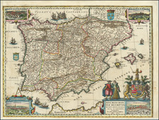
Fine example of this rare map of Minorca, published by Tomas Lopez, in Madrid, in 1780.
Lopez's map was meticulously compiled from a number of Spanish and other sources, including the maps of Agustin de Herrera (1740), Nicholas Bellin, Lempriere (1753), Beaurain (1756), Nolin (1756) and a map published by Francisco Xavier de Garma y Duran (1765). An extensive explanation of how the map was compiled is set forth at the bottom left of the map.
Tomas Lopez was the most important commercial mapmaker working in Spain in the 18th Century. One of a group of printers trained in Paris in the middle of the 18th Century, Lopez would become the official mapmaker to the King of Spain and the most important and prolific map publisher working in Madrid, in the second half of the 18th Century.
Unlike most major European mapmakers, Lopez never published a formal large format atlas. Instead, his maps were available for sale individually or bound up individually to order. Accordingly, it is believed that no two surviving atlases of Lopez maps are the same. Because the maps were primarily sold as individual sheets, all of Lopez's maps are quite rare on the market. This is the first example of Lopez's map of Menorca we have ever seen on the market.
Tomás López de Vargas Machuca (1730-1802) was one of Spain’s most prominent cartographers in the eighteenth century. He was born in Toledo but studied at the Colegio Imperial in Madrid, where he focused on mathematics, grammar, and rhetoric. Along with a small group of colleagues, in 1752 the Spanish government sent López for training in Paris with the renowned geographer Jean Baptiste Bourguignon d’Anville. When he returned to Spain he was named Geógrafo de los dominios de Su Magestad and put in charge of the geographic collections of Charles III. He published many maps, including his fascinating maps of the Americas, and a variety of geography manuals. Some of his most famous maps are of the Iberian Peninsula, part of his large project to create a majestic atlas of Spain. Unfinished in his lifetime, López's children published the Atlas Geográfico de España (Geographical Atlas of Spain) in 1804. It was republished in 1810 and 1830.
![(Spanish Riviera) Plan de la Rade de la Carbouiere avec les Quartiers. . . [Plan of the Road of Carbouiere with the Quarters. . .]](https://storage.googleapis.com/raremaps/img/small/94405.jpg)