|
||

|

|
|

|
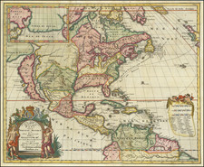
Fine example of the rare proof state of De Leth's handsome separately issued map centered on America and showing the routes of Magellan and the trade route from Europe to Southeast Asia, via Mexico and the west coast of North America.
This example comes from the collection of Glen McLaughlin (letter certifying provenance available on request).
De Leth's map is based largely upon Nicholas De Fer's wall map of 1713. De Leth follows French models and the English American colonies are confined to the Atlantic coast of North America. The Mississippi flows into the Gulf on Mexico on the Texas coast. The Great Lakes are well formed and California is shown as an island. In the Pacific the mythical "Terre de Quir" appears joined to the Australian coastline.
The treatment of Australia, New Zealand and Southeast Asia are also noteworthy. The map shows a continuous southern coastline of Australia running from Terre d'Edels and Terre de Leuwin, regions discover by the Dutch in early 17th Century, to the west coast of New Zealand, suggesting one continuous land mass extending nearly 11 degrees, with "Terre d'Antoine Diemens" sandwiched between cherubs holding aloft a banner describing "Nova Maris Pacifica Tabula . . . " The nearly parallel northern coastline of Australia also extends nearly 11 degrees, trailing off into a fantasy east coast north of the New Zealand Coastline.
The beautifully engraved vignettes include a view of Niagara Falls and a spectacular view of Dutch trading port at the Cape of Good Hope, set within and elaborate border decorated with monkeys and wild cats, and crowned with plan of the fort. A plan of Mexico City is surrounded by scenes of native life and the Spanish Conquest of the native Aztecs, as well as images of the Temple of the sun and an underground mining operation. Other insets includes plans of Straits of Magellan, Table Bay (South Africa); Porto Bello, Straits of Gibraltar; Isthmus of Panama.
Andries de Leth, and his son Hendrik, took over the business of Nicholas Visscher and shortly thereafter produced this magnificent, two-sheet map. The map was not published in any of de Leth's atlases, which accounts for its rarity. As a large separately issued map, subject to the fate of any document unprotected by a binding, it is rarely found in excellent condition.
This is the rare proof state, pre-dating the inclusion of the text box below the Mexico City vignettes (added in the second state) and without the inset city plans of Rio De Janeiro, Havana and Vera Cruz (which replaced a vignette of a waterfall on the Mississippi River) and the publisher's imprint in the second line of the title. The first two editions include insets of the Straits of Magellan and Table Bay, which are changed in the state 3 to insets of Porto Bello and the Isthmus of Panama. This proof state also does not include the inset at the top right (showing the Straits of Gibraltar) and the daily tracks of the route along the west coast of Africa.
State 1 is extremely rare. We have not located another example of this proof state. State 2 is also very rare on the market, although does appear occasionally. An example of state 3 is shown here.
This proof state is very rare on the market. We were unable to locate any other example of the map offered for sale in dealer catalogues or at auction.
![Colton's North America [Wyoming attached to Dakota]](https://storage.googleapis.com/raremaps/img/small/98345.jpg)