|
||

|

|
|

|
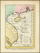
Interesting chart of Eastern Australia and part of the south-western Pacific, showing the routes taken by the Spanish explorer Don Francisco Antonio Maurelle in 1781 along the northern coast of New Guinea and across the Pacific to Fiji and Tonga, including a maunscript grid added in a contemporary hand.
Maurelle was credited with the discovery of the Hermit Islands on this voyage. The map includes the north-eastern coast of Australia, and parts of the coast of New Guinea. The map shows the 1781 route of his ship "The Princesa" through the Bismarck Archipelago north of New Guinea, through the Archipel de Salomos [i.e. Solomon Islands] and then east across the Pacific to the Iles de Amis [i.e. the Friendly Islands, now Tonga] where he discovered I. Vavao [ i.e. Vava'u] with one of the best anchorages in the South Pacific.
The map includes the Iles de Navigateurs [i.e. Samoa], I. Fidji [i.e. Fiji], Iles de Esprit [i.e. Vanuatu or the New Hebrides Isles], and Nouvelle Caledonie [i.e. New Caledonia]. Many small islands are depicted with notes regarding their sightings by Abel Tasman, William Bligh and Maurelle.
A note on the chart states that the publisher has placed the islands according to the longitude of other navigators, rather than on Maurelle's figures which were considered estimates only, and also, that Maurelles chart was based on a French chart by Jacques Nicolas Bellin published in 1742.
La Perouse set sail from France in 1785 to continue the discoveries of Captain Cook. He was shipwrecked in 1788 but his narrative, maps, and views survived and were published in 1797.
![[ Tasmania / Hunter Island ] Carte des Iles Hunter dressee Par L. Freycinet, Commandant la Goelette le Casuarina, d'apres ses observations et celles de Mr. Boullanger Ingenieur Hydrographe -- December 1802. (Rare separately published example)](https://storage.googleapis.com/raremaps/img/small/53891.jpg)
![Asia [with Australia]](https://storage.googleapis.com/raremaps/img/small/72516.jpg)
![[Australia] Ins kleine Gebrachte Karte von den Sud-Laendern Zur Historie der Reisen](https://storage.googleapis.com/raremaps/img/small/93880.jpg)