|
||

|

|
|

|
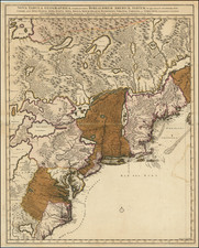
Rare large format map of Maine by Sotzmann prepared for Christopher Ebeling's Erdbeschreibung von Amerika.
Sotzmann's map depicts Maine, and parts of New Brunswick, Quebec and New Hampshire. The geographic detail is particularly strong along the coast of Maine and its complex system of rivers, streams, lakes and ponds south of the 46th parallel. Northern Maine is shown as all but uncharted, except a few major river systems and some ranges of peaks. Sotzmann meticulously depicts the applicable state/national boundaries, county lines, township boundaries, and stage- and post roads.
The map is particularly interesting for its depiction of patterns of land ownership. Massachusetts was perpetually short of cash in the post-Revolutionary years, and its leaders used the unoccupied lands in Maine to raise funds and provide new opportunities for development. The first major effort was a 1786 scheme to sell by lottery dozens of townships in Washington and Hancock Counties, the boundaries of which are clearly visible on the map. Late, the failed Philadelphia financier William Bingham made two massive purchases of one million acres each, both of which are also shown. Other townships were sold scattershot, while some were granted outright to educational and other institutions, and in one case to the "Sufferers of Portland" (aka Falmouth), which had been burned by the British during the Revolution.
North of roughly 44?30' dozens of townships are shown on the map as unclaimed. Sotzmann shows on the map that most of the townships which had changed hands had not yet benefitted from development. For example not a single road is shown in the million or so acres held by Bingham in Hancock and Washington Counties.
Also of the greatest interest is Maine's disputed northern boundary with British Canada. To the east, Sotzmann depicts three alternative boundaries between Maine and New Brunswick, reflecting the British claim, the American claim, and the compromise resolution achieved by a bilateral commission in October, 1798. This eastern boundary was not fully resolved until 1818, when the boundary line was extended through Passamaquoddy Bay. The last of the boundary disputes was finally resolved by the Webster-Ashburton Treaty of 1842.
Thompson describes Sotzmann's map as "undoubtedly one of the finest early maps of Maine." Below the 46th parallel, Sotzmann's map is largely based on Osgood Carleton's Map of the District of Maine, published in 1795 to accompany James Sullivan's History of the District of Maine. There are significant differences. For example, Sotzmann shows the different interpretations of the Maine-New Brunswick border as well as the compromise settlement of 1798. Sotzmann references the townships in southern Hancock and Washington Counties as "Lottery Land," whereas Carleton assigns ownership to William Bingham, while the Waldo Patent along Penobscot Bay is labeled by Sotzmann as "now belonging to Genl. Knox. Sotzmann also offers far more detail than Carleton of adjacent areas of Quebec, New Brunswick and New Hampshire.
Sotzmann's depiction of the northern reaches of Maine, as well as adjoining areas of Quebec and New Brunswick, is completely different, and both more detailed and more accurate than that on Carleton's maps. Sotzmann's source or sources are not certain, though the outline of the Chaudiere River and the upper St. Lawrence strongly resembles that on Sauthier's 1777 Map of the Inhabited Part of Canada, itself derived from earlier French surveys. It also differs interestingly in giving a much more conservative view of the Maine-Quebec boundary, which Carleton had placed almost at the St. Lawrence River.
Christopher Ebeling was a German scholar who undertook an exhaustive study of America. After studying the work of a number of engravers he selected Sotzmann to engrave a set of maps of the states of the United States. Unfortunately, due to an extended illness, Ebeling did not finish the project and only 10 of the maps were published. However, his Atlas of America has become the most celebrated of works. Walter Ristow states that only a handful of North American institutions have examples of all ten maps, making the series among the rarest cartographic Americana for the closing decade of the 18th Century.
We are indebted to Michael Buehler of Boston Rare Maps for the majority of the scholarship which went into this description.
![[New England] Tierra Nueva](https://storage.googleapis.com/raremaps/img/small/64626.jpg)

![[ New England / Northeast / Canada ] Tierra Nueva](https://storage.googleapis.com/raremaps/img/small/86737.jpg)