|
||

|

|
|

|
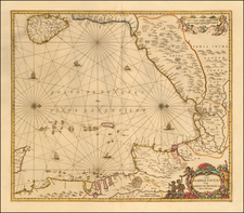
Fine sea chart of the Indian Ocean, published in London by Laurie & Whittle in 1800.
This copy includes the following note: "Track of the Ship Avon Isc. Whittemore, Master, from Boston to the Pacific Ocean 1816." Isaac Whittemore sailed the Northwest Coast of America from 1807 to 1818 when he died off the coast of South America. He traded sea otter and other fur pelts in the Cantonese market. His name appears on a number of occasions in the book Russia's Hawaiian Adventure, 1815-1817, which identifies him as the Captain of the Avon and places in Hawaii (including contact with King Kamehameha), Sitka and the California Coastline. This book places Whittemore at Hanalei Bay in October 1816. It appears that he also served in the American Revolution.
The map title notes that it includes
the tracks of the English, Spanish, French and Dutch navigators and chiefly the track of the Walpole, Eastindiaman, Captn. Thos. Butler, 1794 from the Cape of Good Hope to Van Diemen's Land and from thence to China, and the track of the Royal Admiral Captn. Henr. Bond in 1792 and 93, from the Cape to Port Jackson and China.
Includes a fantastic early treatment of Australia (referred to as New Holland) and New Zealand, reflecting the discoveries in the last decades of the 18th Century. Insets describe the "Discoveries made by the Royal Admiral," "Observations on Walpole's Track" and the tracks and notes relating to many of the other 18th Century voyages of discovery in the Indian Ocean. The coastline of Australia is still incomplete, with annotations along the coast naming and dating the discoveries of various Dutch and Engish explorers.
The map extends east to New Zealand and north to Korea and Japan.
Shortly after this map was annotated by Whittmore, it seems that he became indirectly involved in a scheme to take Hawaii by a Doctor G.A. Schaffer of the Russian American Company.
Robert Laurie (ca. 1755-1836) and James Whittle (1757-1818) formed their Fleet Street, London-based firm upon the 1794 death of their employer Robert Sayer, himself one of the dominant print and mapmakers of the last half of the 18th century.
Laurie & Whittle started managing Sayer's business as early as 1787. They took over all managerial duties when Sayer's health flagged in 1792, and they changed the imprint in 1794 upon his death. Sayer left the two a 21-year lease on the shop (at £100 a year) and on Sayer's Bolt Court premises, as well as an option to acquire stock and equipment at a preferential price of £5,000 payable over three years.
Robert Laurie retired from the firm in 1812, and his role was assumed by his son, Richard Holmes Laurie (1777-1858). The younger Laurie worked with James Whittle until the latter died in 1818. After R. H. Laurie died in 1858, Alexander George Findlay, FRGS (1812-1875) purchased the firm from his daughters. The firm continues today under another name, specializing in yachting charts.
Laurie & Whittle were prolific print and map publishers, and throughout their careers, they produced numerous very important and rare works. They carried on Robert Sayer's atlas business and were responsible for editions of The Complete East-India Pilot and The American Atlas.
![[ Pacific Ocean and America -- The West Indies ] Descripcion De Las Yndias Ocidentales](https://storage.googleapis.com/raremaps/img/small/95683.jpg)