|
||

|

|
|

|
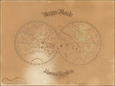
Very rare late edition of the De L'Isle-Buache double hemisphere map of the world, first published in 1720 by De L'Isle and first revised by Buache in 1745.
The map is a marvelous depiction of the routes of Captain James Cook on this 3 voyages between 1773 and 1779.
The map has been revised to show the United States (Etats Uis), a detailed post Vancouver treatment on Alaska and the Northwest Coast of America, a completed (but still conjectural) coastline of Australia, updated configuration for New Zelaland and evidence of early contacts with islands near the Antarctic Circle.
In the northern regions, the discoveries of MacKenzie are shown.
This map was re-issued with updated dates by Dezauche and his heirs well into the 19th Century. We located an example dated as late as 1828, although most examples were dated 1801 or 1808. This is the only example we have located with the 1825 date.
Jean-Claude Dezauche (fl. 1780-1838) was a French map publisher. Initially, his work focused on engraving music, but he later turned primarily to cartography. His is best known for editing and reissuing the maps of Guilluame De L’Isle and Philippe Buache, two of the most skilled mapmakers of the eighteenth century. He acquired the plates of these two men’s work in 1780 from Buache’s heir, Jean-Nicolas Buache. Dezauche's business received a further boon when he received a privilege to sell the charts of the Dépôt de la Marine. His business was carried on by his son, Jean-Andre Dezauche.
![[Early Photographic Facsimile of the Lopo Homem Planisphere of 1554]](https://storage.googleapis.com/raremaps/img/small/67276.jpg)
![[From the Library of Captain Louis Freycinet] Carte Hydrographique Des Partes Connues De La Terre Dressee sur la Projection de Mercator, Poar C.LO. Gressier , Ingenieur Hydrographe de la Marine . . . 1835 (with extensive manuscript annotations)](https://storage.googleapis.com/raremaps/img/small/58604.jpg)