


|
||

|

|
|

|
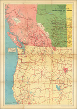
Rare separately issued map of the Military Department of the Platte, published in Omaha for the Secretary of War.
Fine example of William A. Jones' map of the Platte River, prepared during the Indian Campaigns. Captain William A. Jones served as the Chief Engineer of the Department of the Platte. Jones conducted a successful reconnaissance of the headwaters of the Platte, seeking to locate a route for a wagon road from the Union Pacific rail line in northwest Wyoming to Fort Ellis in Montana Territory, His expedition produced a number of important manuscript maps which were subsequently incorporated into field maps of "Nebraska" and "Wyoming", between 1872 and 1874, which were unquestionably primary source maps during the latter part of the campaigns.
The map is one of the best early maps to focus on the Platte River Valley. The map shows military posts, Indian agencies, roads, railroads, rivers, and Indian reservations. The major trails roads between the various military posts are emphasized, along with the hydrography of the region.
The map is exceedling rare. AMPR lists no copies for sale and we can find no auction records for this or any of the other "Military Department of the Platte" maps prepared by Jones.


![[ Used by '49ers To Travel To California ] Map of Oregon and Upper California from the surveys of John Charles Fremont and others authorities drawn by Charles Preuss 1848](https://storage.googleapis.com/raremaps/img/small/100557.jpg)
![(Civil War) Fredericksburg … [with] Map… of the Sioux Expedition [with] Map of the Fight of the 14th A.C. Buzzard Roost, GA [and ] Big Mound [and] Dead Buffalo Lake [and] Dry Fort Creek](https://storage.googleapis.com/raremaps/img/small/97072.jpg)