|
||

|

|
|

|
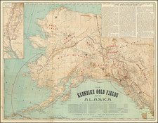
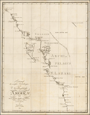
Rare separately issued 4-sheet map of Alaska, published by the Alaska Road Commission.
The map is a monster production, much larger than any other general map of Alaska published in this time period. The Bulletin of the American Geographical Society noted that it was double the size of the map issued in the Brooks Monograph. While it is possible this map was intended to be included in an official report, our copy has never never been folded and we find no record of any other example of the map bound into a report.
The map shows wagon roads, sled roads, pack trails, railroads, telegraph and telephone lines. The note below the scale states that the map was
compiled from Surveys of the Alaska Road Commission, the U.S. Coast and Geodetic Survey, U.S. Geological Survey, U.S. Army Surveys, and the Canadian Geological Survey.
The Board of Road Commissioners for Alaska, more commonly known as the Alaska Road Commission or ARC, was created in 1905 as a board of the U.S. War Department.
Prior to its creation, the Alaska Interior was largely roadless up until about the 1870s, with only a network of trails established by the native people of Alaska, which Russian, and later American, traders and prospectors used as well. The Russians in Alaska stuck to coastal regions, and built almost no new trails or roads during their time of possession (1741 to 1867), and early mining, such as near Sitka was close to the coast. In the 1870s and 1880s, spurred by increased settlement and prospecting, some settlers began making arrangements with the natives, improving trails and in some cases imposing tolls, such as on the Dalton Trail.
Prospectors and others wished for an easier overland route between a year round port in southern Alaska and the Yukon River. The US Army began surveying and determined the best route would be north from Valdez. The Army started construction of a pack trail from Valdez to Eagle in 1898. By 1899 this project was also known as the Trans-Alaska Military Road. In the early 1900s, congressional committees investigating transportation needs in Alaska, including a 1903 visit by a Senate committee on Territories, recommended that the War Department construct a trail system and upgrade the newly built Valdez-Eagle trail to a wagon road. Congress approved legislation establishing a commission to oversee these and other improvements on January 27, 1905, Congress approved legislation establishing a commission to oversee these and other improvements on January 27, 1905 and the Alaska Road Commission (ARC), was organized May 15, 1905, by order of the Secretary of War.
A fine example of this rare map.
The United States Office of the Coast Survey began in 1807, when Thomas Jefferson founded the Survey of the Coast. However, the fledgling office was plagued by the War of 1812 and disagreements over whether it should be civilian or military controlled. The entity was re-founded in 1832 with Ferdinand Rudolph Hassler as its superintendent. Although a civilian agency, many military officers served the office; army officers tended to perform the topographic surveys, while naval officers conducted the hydrographic work.
The Survey’s history was greatly affected by larger events in American history. During the Civil War, while the agency was led by Alexander Dallas Bache (Benjamin Franklin’s grandson), the Survey provided the Union army with charts. Survey personnel accompanied blockading squadrons in the field, making new charts in the process.
After the Civil War, as the country was settled, the Coast Survey sent parties to make new maps, employing scientists and naturalists like John Muir and Louis Agassiz in the process. By 1926, the Survey expanded their purview further to include aeronautical charts. During the Great Depression, the Coast Survey employed over 10,000 people and in the Second World War the office oversaw the production of 100 million maps for the Allies. Since 1970, the Coastal and Geodetic Survey has formed part of the National Oceanic and Atmospheric Administration (NOAA) and it is still producing navigational products and services today.