


|
||

|

|
|

|
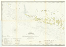
Fine example of this rare engraved edition of the US Coast Survey map of the area between Boca Grande Key and Sugar Loaf Key, centered on Key West, published separately on thick paper as a presentation copy.
A fine example of this separately issued chart centered on Key West and engraved for the coast survey on thick paper, unlike the thin tissue paper copies which were bound into the official reports.
Lengthy tidal observations, notes on light houses, tides, general notes and sailing directions, along with extensive soundings and topographical details.
Printed on thick paper and never folded, the chart is in near fine condition.
The United States Office of the Coast Survey began in 1807, when Thomas Jefferson founded the Survey of the Coast. However, the fledgling office was plagued by the War of 1812 and disagreements over whether it should be civilian or military controlled. The entity was re-founded in 1832 with Ferdinand Rudolph Hassler as its superintendent. Although a civilian agency, many military officers served the office; army officers tended to perform the topographic surveys, while naval officers conducted the hydrographic work.
The Survey’s history was greatly affected by larger events in American history. During the Civil War, while the agency was led by Alexander Dallas Bache (Benjamin Franklin’s grandson), the Survey provided the Union army with charts. Survey personnel accompanied blockading squadrons in the field, making new charts in the process.
After the Civil War, as the country was settled, the Coast Survey sent parties to make new maps, employing scientists and naturalists like John Muir and Louis Agassiz in the process. By 1926, the Survey expanded their purview further to include aeronautical charts. During the Great Depression, the Coast Survey employed over 10,000 people and in the Second World War the office oversaw the production of 100 million maps for the Allies. Since 1970, the Coastal and Geodetic Survey has formed part of the National Oceanic and Atmospheric Administration (NOAA) and it is still producing navigational products and services today.
![The North Coast of the Gulf of Mexico from St. Marks to Galveston . . . 1844 . . . Additions to 1856, including the Surveys of Comr. Powell, Lt. Simmes & Profr. Coffin, U.S. Navy [and] St. Marks to Galveston. Sheet II. . . . 1845. Additions to 1851 . . . .](https://storage.googleapis.com/raremaps/img/small/89497.jpg)
![[ Charleston, Boston, New York, St. Augustine, Bahamas, etc ] Particular Draughts of some of the Principal Towns and Harbours belonging to the English French and Spanish in America and the West Indies.](https://storage.googleapis.com/raremaps/img/small/102804.jpg)
![[ Florida / Georgia Coastline ] A Plan of Amelia Harbour and Bar, in East Florida, Surveyed by Jacob Blamey, Master of His Majesty's Schooner St. John](https://storage.googleapis.com/raremaps/img/small/38028.jpg)
![[ The King of Florida ] Der Konig in Florida](https://storage.googleapis.com/raremaps/img/small/94085.jpg)