|
||

|

|
|

|
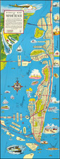
Rare separately issued revised edition of the USCS Chart of the St. Mary's River and Fernandina Harbor, originally issued in 1857.
The present example, which notes at the top left corner notes that it is a "Copperplate Transfer, April, 1863," includes significant topogrpahical features not present on the original 1857 edition of the map. The details would appear to be those which were added by C.O. Boutelle in 1862, but this credit is not included on the map, although it does appear the 1862 edition of the map which appeared in the Annual Report map.
The map shows the the details of the St. Mary's River Delta, along with the towns of St. Mary's and Fernandina. It shows Fort Clinch and Old Fernandina on Amelia Island. The chart contains a wealth of practical information for the mariner including soundings, safe harbors and sailing directions.
We find no record of this edition of the chart.
The United States Office of the Coast Survey began in 1807, when Thomas Jefferson founded the Survey of the Coast. However, the fledgling office was plagued by the War of 1812 and disagreements over whether it should be civilian or military controlled. The entity was re-founded in 1832 with Ferdinand Rudolph Hassler as its superintendent. Although a civilian agency, many military officers served the office; army officers tended to perform the topographic surveys, while naval officers conducted the hydrographic work.
The Survey’s history was greatly affected by larger events in American history. During the Civil War, while the agency was led by Alexander Dallas Bache (Benjamin Franklin’s grandson), the Survey provided the Union army with charts. Survey personnel accompanied blockading squadrons in the field, making new charts in the process.
After the Civil War, as the country was settled, the Coast Survey sent parties to make new maps, employing scientists and naturalists like John Muir and Louis Agassiz in the process. By 1926, the Survey expanded their purview further to include aeronautical charts. During the Great Depression, the Coast Survey employed over 10,000 people and in the Second World War the office oversaw the production of 100 million maps for the Allies. Since 1970, the Coastal and Geodetic Survey has formed part of the National Oceanic and Atmospheric Administration (NOAA) and it is still producing navigational products and services today.


![(Florida-Georgia) Wie der Franzosen Oberster eine Seul / daran das Wapen dess Königes auss Franckreich / aussrichten lassen. [How the French commander had a seal made, on which the coat of arms of the King of France is displayed.]](https://storage.googleapis.com/raremaps/img/small/95828.jpg)