This item has been sold, but you can enter your email address to be notified if another example becomes available.


|
||

|

|
|

|
Stock# 3221
Description
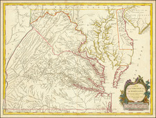
One of the earliest obtainable maps of Tennessee. Extends from the Mississippi in the West to the Appalachians, naming places such as Grand Fathers, Talasse, Kentucky Road, Knoxville, Estenauhly, Chjerokee Town, Creeks Crossing Place, Crow Town, N Nieckajack Town, Clerksville, Nashville, Coyeta, Chota, Chilowee, etc. Locates Indian Villages, Roads, reservation boundaries, etc. An increasing scarce 18th Century map of Tennessee. Wheat & Brun 697.

![(Florida-Georgia) Wie der Franzosen Oberster eine Seul / daran das Wapen dess Königes auss Franckreich / aussrichten lassen. [How the French commander had a seal made, on which the coat of arms of the King of France is displayed.]](https://storage.googleapis.com/raremaps/img/small/95828.jpg)