This item has been sold, but you can enter your email address to be notified if another example becomes available.


|
||

|

|
|

|
Stock# 3173
Description
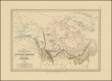
Rare chart of a portion of the Northwest Passage, as charted by Captain Parry in his Arctic Explorations of 1819 and 1820. Th emap shows the region between the southern coast of Melville Island and the Baffin Sea, with extensive place names and notes on North Devon, North Somerset, Cornwalis Island, Prince Regent Pass, Barrow Strait, Lancaster Sound, Grifith Island, Browne Island, Cape Walker, etc. The map was issued in the Volume VII of the Nouvelle Annales du Voyages, the remarkable scientific compendium of the early 19th Century. The map is rarely seen on the market. This is our first example in 10 years.

![[An English Propaganda Map In French] Carte Des Possessions Angloises & Francoises Du Continent De L'Amerique Septentrionale 1755.](https://storage.googleapis.com/raremaps/img/small/86975.jpg)