


|
||

|

|
|

|
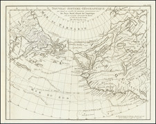
A Cartographic Landmark - Most Complete Map of the North Pacific to Date and the Beginning of the Scientific Debate of the Sea of the West and Northwest Passage
This is a fine example of a first edition of the landmark De L'Isle-Buache map of the North Pacific, exhibiting the recent Russian discoveries for the first time on a printed map.
The map shows North America and Russia arrayed from the North Pole. An advertisement in the upper left corner explains that this map not only shares new geographic discoveries, it also improved upon the stereographic projection. Rather than show meridians and parallels meeting in right angles, the chart includes the curve of the earth, with latitude lines radiating in an arc, making it possible to show more area.
A large sea is in the interior of North America. A series of lakes nearly connects Baffin's Bay to the Mer du Sud, suggesting a Northwest Passage. To the north are glacial mountains while to the west are a series of archipelagoes and several large lakes. Further west, Russia appears well delineated, with the exception of a "Grande Terre" supposedly discovered by the Russians in 1723.
In the top two corners are oval frames containing portrayals of indigenous peoples: to the right a North American native, to the right a Kamchatkan. In the middle is a decorative title cartouche proclaiming the novelty of this map. It also mentions that the map was made by two of the most important mapmakers of the mid-eighteenth century. One was Philippe Buache, premier gèographe du roi, gèographe adjoint to the Acàdemie Royale des Sciences and son-in-law of the famous geographer Guillaume De L'Isle. The other was Joseph Nicholas De L'Isle, astronomer, geographer, and brother to Guillaume. J. N. De L'Isle presented the map to the Acàdemie Royale on April 8, 1750; it was printed in June of 1752.
Russian discoveries
Joseph Nicholas De L'Isle spent much of his career in Russia, where he helped to found the Russian Academy of Sciences. While there, he had access to the latest findings of Russian explorers and was at the center of Russia's geographic establishment; for example, he helped produce the first Russian atlas, the Atlas Russicus, with Ivan Kyrilov. He returned to Paris in 1747 with a large map collection, an event that drew some criticism from Russian academicians who thought he absconded with delicate materials.
The map identifies Russian discoveries from the previous three decades. Two expeditions led by Vitus Behring (1728-30, 1733-43) explored Kamchatka and what is now Alaska, charting the strait between them. De L'Isle interviewed Bering and used his charts from the voyages. Their discoveries are marked with Bering's track in 1731, near Kamchatka, and the new geographic features in the Alaska area.
The map also includes the track of " Capitaine Tchirikow et Mr De l'Isle de la Croyere" in June and July of 1741. De L'Isle's half-brother, Louis De L'Isle de la Croyere, sailed with Captain Alexsei Chirikov (Tchirikov) to discover the fictional De Gama's Land, or Companies Land. Joseph Nicholas was convinced that the island existed and provided his half-brother with maps to support the hypothesis. de la Croyere perished on the voyage, but his brother received his papers and published his findings on the map.
Beyond the Russian discoveries, the map also shows the track of the 1743 Spanish galleon from Manila to Acapulco, as well as de Frondat's voyage of 1709. A Frenchman, de Frondat followed the usual galleon route and attempted to trade with Spanish settlers once he reached Baja California. He later sold his goods in Peru and Chile and returned home with a fantastic £2,000,000. Another note shows a small stream leading west from Hudson's Bay. This is Wager Inlet, first probed by Christopher Middleton in the early 1740s and supposedly one of the possible sources of a Northwest Passage.
Sea of the West
While the map integrates the latest Russian explorations, it also re-invigorates the mythical Sea of the West, which had first appeared on charts published by Johann Baptiste Nolin in ca. 1700, but had quickly disappeared thereafter. In contrast, a dominant feature of this map is a vast " Mar ou Baye de l'Ouest," which stretches from 43°to 60°N.
The re-introduction of the sea was the result of Buache's review of his father-in-law's papers. Although Guillaume De L'Isle never published a map showing the sea, he had postulated that it could exist, and that it might connect to a Northwest Passage through New France, not through English territory farther north. Nolin had plagiarized the idea from Guillaume, as the latter testified when suing the former for plagiarism. He said, the Sea of the West "was one of my discoveries. But since it is not always appropriate to publish what one knows or what one thinks one knows, I have not had this sea engraved on the works that I made public, not wanting foreigners to profit from this discovery" (as quoted in Pedley, 109.
Martin Aguilar, Juan de la Fuca, and Admiral de la Fonte
The Pacific Northwest shown here is defined by the discoveries of three men, Martin Aguilar, Juan de la Fuca, and Admiral De Fonte, all of which were to prove dubious at best. The former navigator was a Spanish captain who sailed with Sebastian Vizcaino on a reconnaissance expedition up the California coast in 1602-3. Aguilar, commanding the Tres Reyes, was blown off course, to the north. When the seas calmed, Aguilar reported that he had found the mouth of a large river. Eighteenth-century geographers, including De L'Isle and Bauche, conjectured that the river was the entrance to the Sea of the West, as it is positioned on this map.
There is another entrance to the sea, this one labeled as the discovery of Juan de la Fuca. The authors are referring to Juan de la Fuca, the Castilianized name of Greek navigator Ioánnis Fokás (Phokás). Little archival evidence survives of Fuca's career, but a chance meeting with an English financier, Michael Lok, in Venice in 1596 gave birth to rumors of Fuca's voyages in the Pacific. Fuca reported that he had been sent north from New Spain twice in 1592 in search of the Strait of Anian. The Spanish Crown failed to reward Fuca's discovery of an opening in the coast at roughly 47° N latitude and Fuca left the Spanish service embittered. His story lived on in Lok's letters and eventually was published in Samuel Purchas' travel collection of 1625. On many eighteenth-century maps, including this one, Fuca's Strait is linked with a River or Sea of the West. In 1787, the present-day Juan de Fuca Strait was named by the wife of naval explorer Charles William Barkley, making permanent a label that had previously just been hopeful conjecture.
Even farther north, there is a Lac de Fonte connected to a series of lakes and a Rio de los Reyes. Admiral de Fonte supposedly sailed to the area in the mid-seventeenth century. The first mention of Fonte appears in two letters published in London in 1708 in two issues of The Monthly Miscellany or Memoirs for the Curious. The Fonte letters had been reprinted by Arthur Dobbs in his 1744 An Account of the Countries adjoining Hudson's Bay and were mentioned in other travel accounts . Delisle's copy of the letters came from Lord Forbes, British ambassador to Russia, as he explained in a memoir, Nouvelles Cartes des Decouvertes de l'Amiral de Fonte (Paris, 1753). He also read of them in Henry Ellis' account of the 1746-7 expedition to Wager Inlet.
The letters recounted that Fonte had found an inlet near 53°N which led to a series of lakes. While sailing north east, Fonte eventually met with a Boston merchant ship, commanded by a Captain Shapley. One of Fonte's captains, separated from the Admiral, reported he had found no strait between the Pacific and the Davis Straits, yet had reached 79°N, helped by local indigenous peoples. This story, with its suggestion of water passages connecting the Pacific Northwest with the east, inspired hope in some and doubt in others in the mid-eighteenth century. A few, like Irish mapmaker John Green, thought the entire story a farce. Many, including De L'Isle and Buache, thought the information conformed neatly to other recent discoveries and included Fonte on their map.
In this June 1752 map, Fonte's entrance is at roughly 63°N latitude. In the face of criticism, De L'Isle published another map in September 1752 moving the entrance to 53°N, as the letters had stated. This caused a rift between De L'Isle and Buache, as the latter stuck to the initial misreading of the letters. In this second map, the Mar de l'Ouest is significantly smaller than on the first. Both men, however, continued to believe Fonte a credible source and continued to include him on their maps in some capacity.
All three men's discoveries, real or exaggerated, reshaped the Pacific Northwest for the next thirty years, until the discoveries by James Cook of the area between Alaska and Puget Sound. This is a landmark map in the history of cartography and perhaps the single most influential map of the region in the middle of the eighteenth century.
Warren Heckrote and Edward H. Dahl, "George le Rouge, Vitus Bering, and Admiral la Fonte: a Cautionary Tale about "Cartographic Firsts"" The Map Collector 64 (autumn 1993): 18-23.
Lucie Lagarde, "Le Passage du Nord-Ouest et la Mer du l'Ouest dans la Cartographie Francaise du 18e Siecle," Imago Mundi 41 (1989): 19-43.
Mary Sponberg Pedley, The Commerce of Cartography: Making and Marketing Maps in Eighteenth-Century France and England (Chicago: University of Chicago Press, 2005).
H. R. Wagner, "Apocryphal Voyages to the Northwest Coast of America," Proceedings of the AAS XLI (1931): 179-234.
Glyndwr Williams, “An eighteenth-century Spanish investigation into the apocryphal voyage of Admiral Fonte,” Pacific Historical Review 30, no. 4. (1961): 319-327.
Philippe Buache (1700-1773) was one of the most famous French geographers of the eighteenth century. Buache was married to the daughter of the eminent Guillaume Delisle and worked with his father-in-law, carrying on the business after Guillaume died. Buache gained the title geographe du roi in 1729 and was elected to the Academie des Sciences in the same year. Buache was a pioneering theoretical geographer, especially as regards contour lines and watersheds. He is best known for his works such as Considérations géographiques et physiques sur les découvertes nouvelles dans la grande mer (Paris, 1754).
![[Japan] Carte Des Decouvertes au Nord du Japon Faites en 1643 par les Vaisseaux Hollandais le Kastrkum et le Breskens, Comprenant la Terre de Jeso, I'Ile des Etats et la Terre de Compagnie, dont partie a ete reconnue en 1787 . . .](https://storage.googleapis.com/raremaps/img/small/49803.jpg)
![Plan du Typa ou de Macao [with] Plan De La Baye D'Awatwska…Du Kamtschatka [with] Parti Du Japon ou Nipon](https://storage.googleapis.com/raremaps/img/small/36150.jpg)

![(China) КАРТА КИТАЙСКAГО ГОСУДАРСТВА. [Map of the Chinese State.]](https://storage.googleapis.com/raremaps/img/small/56505.jpg)