|
||

|

|
|

|
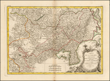
Fine, Detailed Map of Eastern Asia
Notable example of this meticulously-drawn map of East Asia and the Indian subcontinent published in Paris. The map is based upon the earlier work of the famed geographer Guillaume De L'Isle and was re-issued by his son-in-law, Philippe Buache.
The map covers much of Asia, from China and Japan, south to New Guinea and the Moluccas, west through Malaysia and Indonesia to what is today Vietnam and Thailand, and India.
Dotted lines mark political boundaries. The map is thickly detailed with settlements, geographic features, and ethnographic notes. There is a simple title cartouche in the top center, with a quadruple scale bar in the upper right corner.
While most of the outlines of the continent appear familiar to the modern eye, the landmass north of Japan may prove surprising. Here, the “Terre de Yeco ou d’Eso.” Yeco is a reference to Jesso, a feature included on many seventeenth and eighteenth-century maps. Historically, Eso (Jesso, Yedso, Yesso) refers to the island of Hokkaido. It varies on maps from a small island to a near-continent sized mass that stretched from Asia to Alaska.
Guillaume De L’Isle
The thoroughness of the information included here, and its density, is characteristic of Guillaume De L’Isle, who originally drafted the map. Guillaume De L'Isle (1675-1726) is probably the greatest figure in French cartography. Having learned geography from his father Claude, by the age of eight or nine he could draw maps to demonstrate ancient history. He studied mathematics and astronomy under Cassini, from whom he received a superb grounding in scientific cartography—the hallmark of his work. His first atlas was published in ca. 1700. In 1702 he was elected a member of the Academie Royale des Sciences and in 1718 he became Premier Geographe du Roi.
De L'Isle's work was important as marking a transition from the maps of the Dutch school, which were highly decorative and artistically-orientated, to a more scientific approach. He reduced the importance given to the decorative elements in maps, and emphasized the scientific base on which they were constructed. His maps of the newly explored parts of the world reflect the most up-to-date information available and did not contain fanciful detail in the absence of solid information. It can be fairly said that he was truly the father of the modern school of cartography at the commercial level.
De L’Isle also played a prominent part in the recalculation of latitude and longitude, based on the most recent celestial observations. His major contribution was in collating and incorporating this latitudinal and longitudinal information in his maps, setting a new standard of accuracy, quickly followed by many of his contemporaries. Guillaume De L’Isle’s work was widely copied by other mapmakers of the period, including Chatelain, Covens & Mortier (as seen here), and Albrizzi.
Siam
Many of the political units shown on this map, like Japan and China, are still active and similarly named today. Others, like Siam and the Mughal Empire, are less recognizable. What is modern Thailand is labeled as Siam. Siam comes from the Sanskrit word “syam,” which the Portuguese adopted as a name for the region.
The extent of their territory varied over time, as shown here with Siam and Haut-Siam. During the eighteenth-century, the polity was on the rise and expanding. By the 1780s, the Chakri dynasty ruled all of Siam from Bangkok, their capital, in addition to part of the Malay peninsula, Laos, and Cambodia.
However, in the nineteenth and twentieth centuries Siam lost land to the French, who colonized much of Cochinchina. In 1932, the monarchy was toppled with a coup; it survived, but no longer ran the country. The new leader, Phibun, changed the country’s name to Thailand in 1938.
The Mughal Empire
Another political entity that is unfamiliar to the modern eye is the Mughal Empire, in the north of the Indian subcontinent. By the time this map was published, the Mughals controlled not only the area shown here, but much of the southern peninsula as well.
The Mughal Empire began when Babur (r. 1526-1530), originally from Central Asia, established himself in Kabul, Afghanistan and marched south into India via the Khyber Pass. His descendants consolidated power and fought off rivals. Particularly under the rule of Akbar (r. 1556-1605), the Mughal Empire developed an imperial structure characterized by tolerance of religious differences and a competent administrative elite.
Later in the seventeenth century, the Mughal Empire developed not only as a center of arts and culture—the Taj Mahal was built during this time—but as a political and economic power house. By 1707, under the controversial ruler Aurangzeb (r. 1658-1707), the Mughal Empire reached its largest extent, encompassing much of the Indian subcontinent.
By the time this map was published, however, the empire was beginning to decline. Many of the areas that had been added by Aurangzeb were in open revolt and the dynastic line was in chaos. In 1719, four separate emperors ruled. The Mughal Empire began to lose land and influence, particularly in the face of Maratha opposition and the arrival of the British East India Company.
Philippe Buache (1700-1773) was one of the most famous French geographers of the eighteenth century. Buache was married to the daughter of the eminent Guillaume Delisle and worked with his father-in-law, carrying on the business after Guillaume died. Buache gained the title geographe du roi in 1729 and was elected to the Academie des Sciences in the same year. Buache was a pioneering theoretical geographer, especially as regards contour lines and watersheds. He is best known for his works such as Considérations géographiques et physiques sur les découvertes nouvelles dans la grande mer (Paris, 1754).
![[Nepal] Latest Trekking Map North North of Jomsom Jomsom to Mustang](https://storage.googleapis.com/raremaps/img/small/44106.jpg)