|
||

|

|
|

|
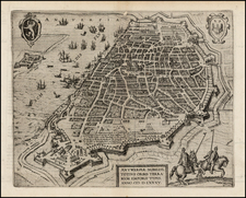
The Spanish Blockade on the Scheldt River in 1584.
Finely engraved view of the area around Antwerp, engraved by Franz Hogenberg, from the 1588 edition of Michael Aitzinger's important early history of the Low Countries.
The map shows the blockade of the Sheldt River, part of the Siege of Antwerp in 1584. The Duke of Parma would lay siege to Antwerp beginning in 1584. One his most important manuvers ws to cut off all access to Antwerp from the sea by constructing a bridge of boats across the Scheldt from Calloo to Oordam.
The map depicts the theater of the operations of the Duke of Parma, Alexander Farnes (1545 – 1592) an Italian noble, who served as Governor of the Spanish Netherlands from 1578 to 1592. He is best known for his successful campaign 1578-1592 against the Dutch Revolt, in which he captured the main cities in the south (now Belgium) and returned them to the control of Catholic Spain.
Michael Aitzinger was an Austrian nobleman, diplomat, historian, and publicist, who wrote and published several works, including a renowned volume that states the principles of a genealogical numbering system. His most famour cartograph work was Novus de Leone Belgico, first published in 1583 that included the first cartographic representation of the Low Countries as Leo Belgicus. The lion motif was inspired by the heraldic figures that appear in the coats of arms of several Dutch constituencies, as well as in the arms of William of Orange. .
![[Low Countries ] Belgium Foederatum emendate auctum et novissime editum](https://storage.googleapis.com/raremaps/img/small/98432.jpg)
![Carte Nouvelle Des Pais Bas Catholiques Devises en Autrichiens, Franscois en hollandois…MDCCXCII [New Map of the Catholic Low Countries Divided into Austrians, French and Dutch... 1792.]](https://storage.googleapis.com/raremaps/img/small/92341.jpg)