|
||

|

|
|

|
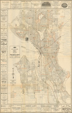
Early promotional map of the City of Spokane Falls (Spokane), Washington, which includes facts and figures encouraging early settlers, published at the beginning of Spokane's major boom period and at the time the Union Pacific Railroad was first arriving in Spokane.
This is quite possibly the earliest commercial promotional map of Spokane Falls, along with an undated map entitled Pocket map of Spokane Falls, Washington Territory, published by the Graphic Illustrating Co.
The map was published for Strobach and Munter, Real Estate Agents, in the year after Spokane's great fire destroyed a significant part of the town. Includes the location of major subdivisions, the railroad lines and vignette of Spokane Falls.
Beginning in the 1830s and 1840s, American settlers began coming to the then Oregon Country by the Oregon Trail. The first American settlers, squatters in the Spokane area, J.J. Downing and S.R. Scranton, built a cabin and established a claim at Spokane Falls in 1871. Together they built a small sawmill on a claim near the south bank of the Spokane Falls. James N. Glover and Jasper Matheney, Oregonians passing through the region in 1873, recognized the value of the Spokane River and its falls. They bought the claims of 160 acres and the sawmill from Downing and Scranton for a total of $4,000.[ Glover and Matheney knew that the Northern Pacific Railroad Company had received a government charter to build a main line across this northern route. Glover later became known as the "Father of Spokane".
In 1880, Fort Spokane was established by U.S. Army troops under Lt. Col. Henry Clay Merriam 56 miles northwest of Spokane at the junction of the Columbia and Spokane Rivers to protect the construction of the Northern Pacific Railway and secure a place for U.S. settlement. By 1881, the Northern Pacific Railway was completed, bringing major European settlement to the area. The city of Spokan Falls (the "e" was added in 1883 and "Falls" dropped in 1891) was officially incorporated as a city of about 1,000 residents on November 29, 1881.
The city's population ballooned to 19,922 in 1890, and 36,848 in 1900 with the arrival of the railroads. After the 1883 discovery of gold, silver, and lead in the in the Coeur d'Alene region of northern Idaho, this precipitated a rush of prospectors into the region. The Inland Empire erupted with numerous mining rushes from 1883 to the late 19th century. Mining emerged as a major stimulus to Spokane. At the onset of the initial 1883 gold rush near Coeur d'Alene, Spokane became the outfitter of choice among prospectors due to the areas proximity, lower prices, and convenience of being able to obtain everything "from a horse to a frying pan". It would keep this status for subsequent rushes in the region due to its' trade center status and accessibility to railroad infrastructure.
Spokane's growth continued unabated until August 4, 1889, when a fire, now known as The Great Fire, destroyed the city's downtown commercial district.
After The Great Fire of 1889 and the rebuilding of the downtown, the city was reincorporated under the present name of "Spokane" in 1891. Just three years after the fire, in 1892, James J. Hill's Great Northern Railway had arrived in the newly created township of Hillyard (annexed by Spokane in 1924)-the chosen site for Hill's rail yards. The railroads in Spokane made it a transportation hub for the Inland Northwest region.
The map is very rare, with OCLC locating only the copy at the Washington State University.
![The Famed Triangle Tour of the Canadian Rockies [Canadian Rockies and the Pacific Coast]](https://storage.googleapis.com/raremaps/img/small/91631.jpg)
![[ Lake Cavenaugh - Lake Creek - Skagit County ] Township No. 33 North, Range No. 6 East, W.M. Wash.](https://storage.googleapis.com/raremaps/img/small/101848.jpg)
![[ Yakima Valley ]](https://storage.googleapis.com/raremaps/img/small/96619.jpg)