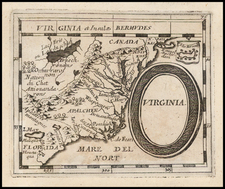
|
||

|

|
|

|
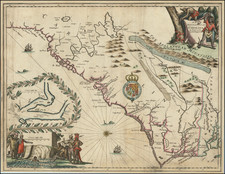
French edition of Sayer & Bennett's detailed sea chart of the area around Hilton Head, South Carolina, based upon a survey by Captain John Gascoigne.
Gascoigne's finely engraved chart was produced at the beginning of the American Revolution, at a time when the outcome among the combatants was still very much in doubt. The chart covers the coastal region of South Carolina, from Port Royal Sound in the north, down past the mouth of the Savannah River and Tybee Island, Georgia, in the south,centered on Hilton Head Island (called "Trench's Island") and "D'Awfoskee Sound," which is today known as Calibogue Sound.
The area around Hilton head was first settled in 1562 byJean Ribaut, who founded a Huguenot settlement called Charlesfort, which was soon destroyed by the Spanish. The Spanish founded the fort and Jesuit mission of Santa Elena in 1566.
Hilton Head was named in 1663 by Captain William Hilton, on a reconaissance mission from Barbadoes, shortly after the creation of the Carolina Colonial Grant in 1661. English settlers arrived in the region in the 1670s, but it was not until 1717 that the first Englishman, Col. John Barnwell settled on Hilton Head, having been given a grant of 100 acres in the northwest corner of the island.
This sea chart was one of the most detailed and accurate of any of the American coastline. The map is based upon the surveys of Captain John Gascoigne in 1728, assisted by his brother James. In 1729, the chart was corrected and improved by Francis Swaine, before languishing until it was published by William Faden and by Sayer & Bennett in 1776.
The area was the site of extensive naval battles in 1778 and 1779, with the British led by General Augustin Prevost, who seized Savannah in December 1778 and the Amercans, led by General William Moultrie, who successfully defended he Ameican positions at Hilton Head in September 1778.
The chart was originally issued in 1773 by Faden, with later issued in 1776 and 1790 by Sayer & Bennett, and re-engraved by Le Rouge for a French edition in 1776. All editions of the map are very rare.
The Le Rouge edition was issued by the French at the commencement of the American Revolution, as part of an atlas prepared for the French Military for use in aid of the American Colonists.
The maps was included in Le Rouge's rare North American Pilot, an atlas of Sea Charts compiled by the French Government and utilized by the French Navy during their participation in aid of the Americans during the American Revolutionary War.

![[ Method by which native Floridians discuss matters of grave importance ] Qua ratione Floridenses de seriis rebus deliberant. XXIX.](https://storage.googleapis.com/raremaps/img/small/97363.jpg)