


|
||

|

|
|

|
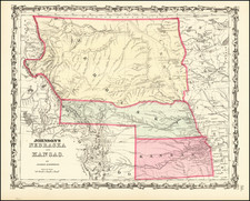
Good example of this rare early travel guide for Iowa Territory, published in New York by J.H. Colton only months after the formation of the Territory.
Colton's Guide is quite likely the earliest printed guide book to focus exclusively on Iowa Territory. By an Act of 12 June 1838, Iowa, until then part of Wisconsin Territory, was made a territory, with its eastern boundary the Mississippi River to its source, then to the Canadian Boundary. In the two years from 1836 to 1838 its population had doubled, being 22,859 in 1838.
In describing the second edition of 1840, Rumsey notes:
Eberstadt: "A very rare guide, with a description of the new territory, its government, judiciary, counties, population, list of townships etc." The map shows the eastern part of the Iowa Territory, along the Mississippi River, and is more detailed than the General Land Office survey maps of 1839-40.
In comparing the two editions, we note changes in the southern half of the map, including the addition of Washington County and Jefferson County, and the reconfiguration of Louisa County. Slaughter County (which appears on the 1839 edition) no longer exists, having been aborbed by Louisa and the newly created Washington County. In Frank Harmon Garver's HIstory of the Establishment Of Counties in Iowa, Iowa Journal of History and Politics, Volume 6 at page 393-94, published in 1908, the author notes that two errors in the map:
The map contains two errors; (1) The boundary line between Johnson and Slaughter counties is placed one township two far north, making Slaughter County four townships square or equal to Johnson in size and (2) . . . the boundary line between Des Moines and Lee counties where the line betwen the townships 68 and 69 is made the boundary whereas the Skunk Rier actually formed the boundary for about six miles.
The present example includes a pastedown bookplate for a stationery store in St. Lewis and the name of an early owner (Andrew Miller).
The guidebook and map are of the utmost rarity. The last example to appear on the market was the Streeter Copy, which brought $400 in 1967. Prior to Streeter, Midland catalogued the book in 1959 ($225.00--likely the Streeter copy) and the C.G. Littell copy was sold at auction in 1945 for $190.00. These are the only reported sales in the 20th Century. Eberstadt listed a second edition of the guidebook (1840) for $125.00 in 1954. Rumsey also has a copy of the 2nd edition.
G. W. & C. B. Colton was a prominent family firm of mapmakers who were leaders in the American map trade in the nineteenth century. Its founder, Joseph Hutchins Colton (1800-1893), was a Massachusetts native. Colton did not start in the map trade; rather, he worked in a general store from 1816 to 1829 and then as a night clerk at the United States Post Office in Hartford, Connecticut. By 1830, he was in New York City, where he set up his publishing business a year later.
The first printed item with his imprint is dated 1833, a reprint of S. Stiles & Company’s edition of David Burr’s map of the state of New York. He also printed John Disturnell’s map of New York City in 1833. Colton’s next cartographic venture was in 1835, when he acquired the rights to John Farmer’s seminal maps of Michigan and Wisconsin. Another early and important Colton work is his Topographical Map of the City and County of New York and the Adjacent Country (1836). In 1839, Colton began issuing the Western Tourist and Emigrant’s Guide, which was originally issued by J. Calvin Smith.
During this first decade, Colton did not have a resident map engraver; he relied upon copyrights purchased from other map makers, most often S. Stiles & Company, and later Stiles, Sherman & Smith. Smith was a charter member of the American Geographical and Statistical Society, as was John Disturnell. This connection would bear fruit for Colton during the early period in his career, helping him to acquire the rights to several important maps. By 1850, the Colton firm was one of the primary publishers of guidebooks and immigrant and railroad maps, known for the high-quality steel plate engravings with decorative borders and hand watercolors.
In 1846, Colton published Colton’s Map of the United States of America, British Possessions . . . his first venture into the wall map business. This work would be issued until 1884 and was the first of several successful wall maps issued by the firm, including collaborative works with D.G. Johnson. From the 1840s to 1855, the firm focused on the production of railroad maps. Later, it published a number of Civil War maps.
In 1855, Colton finally issued his first atlas, Colton’s Atlas of the World, issued in two volumes in 1855 and 1856. In 1857 the work was reduced to a single volume under the title of Colton’s General Atlas, which was published in largely the same format until 1888. It is in this work that George Woolworth (G. W.) Colton’s name appears for the first time.
Born in 1827 and lacking formal training as a mapmaker, G. W. joined his father’s business and would later help it to thrive. His brother Charles B. (C. B.) Colton would also join the firm. Beginning in 1859, the General Atlas gives credit to Johnson & Browning, a credit which disappears after 1860, when Johnson & Browning launched their own atlas venture, Johnson’s New Illustrated (Steel Plate) Family Atlas, which bears Colton’s name as the publisher in the 1860 and 1861 editions.
J.H. Colton also published a number of smaller atlases and school geographies, including his Atlas of America (1854-56), his Illustrated Cabinet Atlas (1859), Colton’s Condensed Cabinet Atlas of Descriptive Geography (1864) and Colton’s Quarto Atlas of the World (1865). From 1850 to the early 1890s, the firm also published several school atlases and pocket maps. The firm continued until the late 1890s, when it merged with a competitor and then ceased to trade under the name Colton.


![[ Northern Pacific Railroad ] NEW 7-30 GOLD LOAN OF THE Northern Pacific Railroad Co. SECURED BY FIRST MORTGAGE ON RAILROAD AND LAND GRANT. SAFE! PROFITABLE! PERMANENT!](https://storage.googleapis.com/raremaps/img/small/101828.jpg)
![[ First Map of the Great Lakes ] La Louisiana, Parte Settentrionalle, Scoperta sotto Protettione di Luigi XIV, Re di Francia . . .](https://storage.googleapis.com/raremaps/img/small/99094.jpg)