


|
||

|

|
|

|
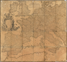
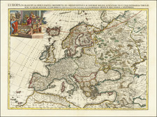
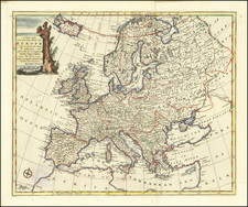
Rare decorative map of Europe, published in Bologna by Francesco Sabatini and engraved by Pietro Todeschi.
Decorative and very rare carte-à-figures map of Europe, including 12 City views across the top and bottom of the map and 10 vignettes of national the typical dress of Europeans in various countries along the left and right.
The map was published by Sabatini, one of the more obscure Italian mapmakers of the late seventeenth century. Little is known about Sabatini, who was apparently active as a printer and publisher (and possibly engraver) in the 1670s, probably in Bologna. This map is a late piracy of Dutch cartes-à-figure maps, popularized in the first part of the seventeenth century, although it seems likely that the map was plagiarized from intermediate Italian copies, perhaps by Stefano Scolari, an engraver and publisher active from the 1640s to 1660s.
Francesco Sabatini, also known as Franciscus Sabadinus, remains a somewhat obscure figure in the realm of Italian map publishing during the sixteenth and seventeenth centuries. The precise details of his life and work are still subjects of ongoing research.
Evidence suggests that he was active as a printer, publisher, and possibly engraver in the 1670s, likely based in Bologna, and was the publisher of several maps by Pietro Todeschi which do not bear Sabatini's name.
Sabatini is known for three exceptionally rare maps, each featuring dedications signed by him. These maps reflect his engagement with contemporary cartographic models and prominent figures of his time:
-
Map of the Holy Roman Empire: This map was modeled after an earlier work by Pieter van den Keere and dedicated to Enea Silvio Caprara (1631-1701), a native of Bologna and an officer serving the imperial house in Vienna. The dedication aligns with Caprara's rank in the early 1670s, suggesting Sabatini's awareness of his patron's prestigious position.
-
Map of the Netherlands: This map was based on a model published in 1672 in Rome by François Collignon. It was dedicated to Francesco del Giudice (1647-1725), who served as a legate of the Holy See in Bologna during the early 1670s. Sabatini's choice of dedicatee reflects his connections with influential ecclesiastical figures.
-
Map of the Iberian Peninsula: Also derived from a model by Pieter van den Keere, this map was dedicated to the Bologna patrician Bartolomeo Manzoli († after 1676). Notably, the map includes a portrait of King Charles II of Spain (1661-1700), depicted as a child, indicating its creation during the early years of Charles's reign.
These maps exemplify Sabatini's contribution to the cartographic traditions of his time, demonstrating his ability to blend contemporary geographical knowledge with the demands and tastes of his distinguished patrons.

![[ Through Cooperation to Communism ] Spolupraci ke Komunismu](https://storage.googleapis.com/raremaps/img/small/97646.jpg)