


|
||

|

|
|

|
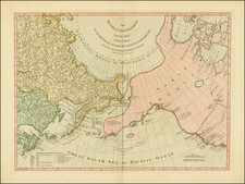
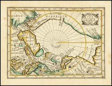
Rare map of the North Polar regions, which appeared in Picart's Tresor des carte Geographiques, published in Paris.
Picart's map is based upon Jansson's map of the North Pole, published in his Atlas Minor in 1628. The first French version of the map was published by Jean Boisseau in 1643, followed by this rare map by Picart, first published in 1651. The present example is the 2nd state of Picart's 1651 map, with the name Destroit d'Anian added top center and the word "le" added in the title. Hudson Bay and Estotilande also both appear for the first time in this edition of the map.
The map provides an exceptionally detailed look at the North Polar regions, includingmythical islands and a surprising use of English nomenclature and language in the area around Hudson's Strait and Davis' Strait.
The map is extremely rare, with no appearances in AMPR in the past 30 years.