|
||

|

|
|

|
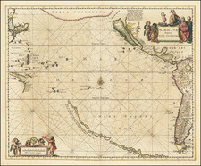
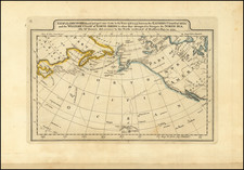
Rare map of North America first published by Paolo Forlani in 1565, the first separately published map of North America.
This is the first map of North America and the first map to show the Straits of Anian.
Paolo Forlani's rare and finely engraved map of North America is one of the most significant early maps of America. It is the earliest printed map devoted solely to North America, the first to portray that landmass as a separate continent and the first to show the so-called Strait of Anian separating America from Asia at the approximate location of the Bering Strait.
Forlani based his map on Giacomo Gastaldi's world map. Gastaldi had been the first to formulate the concept of the Strait of Anian, a name that probably originated with Ania, a Chinese province mentioned in a 1559 edition of Marco Polo's travels. Forlani's early graphic depiction of Gastaldi's mistaken theory, which persisted well into the 18th century, makes this map a cornerstone work in the mapping of America.
In the early 1560s, Forlani also published a map of South America and the West Indies, La descrittione de tutto il Peru ( /gallery/detail/29848 ), and with his North America he completed his coverage of the New World. The map stretches from Greenland down the coast of Canada and the Atlantic Seaboard to the West Indies, including a corner of South America, and from the coast of China in the west to the Azores and Cape Verde in the east.
Until the late 20th Centuiry, the map was attributed to Venetian publisher Bolognino Zaltieri, whose name and imprint appear on the second state, published in 1566. As David Woodward has demonstrated, however, authorship should be ascribed to Forlani, who sold some copperplates - including, presumably, the one used to print this map - to Zaltieri sometime around late 1565 or early 1566.
An extremely rare example of this fascinating map, a landmark in the history of the mapping of America. The present example is the second edition, published by Bolognini Zaltieri. The first edition by Forlani was unknown until the later part of the 20th Century.
Paolo Forlani (fl. ca. 1560-1571) was a prolific map engraver based in Venice. All that is known of his life are his surviving maps and prints, of which there are almost 100 (185 with later states included in the total). He also produced a globe and two town books. It is likely he came from Verona and that he died in Venice in the mid-1570s, possibly of the plague.