


|
||

|

|
|

|
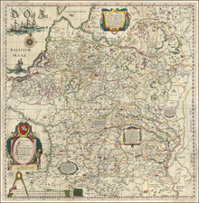
Old color examle of this important 4 sheet wall map of Lithuania and parts of Poland, Russia, Ukraine, Latvia, etc, extending to Cracow, Kiev, Warsaw, Riga, Konigsberg, Dantzig, Leopolis, etc,
The map was engraved by Hessel Gerritsz from original drafts prepared under the instructions of Prince Nicolas Christophe Radziwill, and first issued in 1613 by Willem Blaeu, under his original imprint Guilhelmus Janssonis. This is one of the earliest maps published by Blaeu, who did not incorporate this map into an atlas until approximately 1630.
Thie Radziwill map is one of the most important works of European cartography from the end of the 16th and the beginning of the 17th century and is an important contribution to the progress in the mapping of the whole continent. The map had its beginning in 1586 when Prince Michael Radziwill commissioned M.Strubicz to survey the entire Lithuanian state which then included Poland. Strubicz's map was so accurate and detailed that it provided the basis for all subsequent maps of the area during the 17th and 18th centuries. In addition to the usual topographical details, there is considerable historical information also provided.
The magnificent engraving by the well-known Gerard Hesselsz. includes the Lithuanian coat of arms within an elaborate cartouche, an ornate title piece of scroll work, a wind rose, and three ships in full sail on the Baltic Sea. Buczek remarks that "the map ... occupies a very prominent position among ... European cartography ... and ... was also a great step forward in the mapping of the lands then forming part of Poland ... there are on the map 1020 towns and villages and within the boundaries of the Grand Dutchy of Lithuania alone there are 511 towns, 31 villages, and 1 monastery. "(History of Polish Cartography, p.58-63).
The map is richly embellished with cartouches, a compass rose, sailing ships and a coat of arms.
States
Adamovitch lists 7 states:
- Wall map, no verso text.
- 1631. First Latin edition. No text along the lower edge.
- 1631. Second Latin Edition. Signature HHHHHH on verso of the lower left sheet of Lithuania.
- 1634. German edition. Signatures O or N on map of Dniapro.
- 1635-1649. Various.
- 1643. Period included after phrase Ducatus Severiensis Pars.
- 1645. City name Der Memel included.
Willem Janszoon Blaeu (1571-1638) was a prominent Dutch geographer and publisher. Born the son of a herring merchant, Blaeu chose not fish but mathematics and astronomy for his focus. He studied with the famous Danish astronomer Tycho Brahe, with whom he honed his instrument and globe making skills. Blaeu set up shop in Amsterdam, where he sold instruments and globes, published maps, and edited the works of intellectuals like Descartes and Hugo Grotius. In 1635, he released his atlas, Theatrum Orbis Terrarum, sive, Atlas novus.
Willem died in 1638. He had two sons, Cornelis (1610-1648) and Joan (1596-1673). Joan trained as a lawyer, but joined his father’s business rather than practice. After his father’s death, the brothers took over their father’s shop and Joan took on his work as hydrographer to the Dutch East India Company. Later in life, Joan would modify and greatly expand his father’s Atlas novus, eventually releasing his masterpiece, the Atlas maior, between 1662 and 1672.
Hessel Gerritsz (1581-1632) was a noted Dutch mapmaker, engraver, and publisher who was also the official hydrographer of the Dutch East India Company. Gerritsz was born in Assum. His first exposure to mapmaking was as an apprentice to Willem Janszoon Blaeu, beginning in 1607. In 1610, Gerritsz began his own publishing business.
Gerritsz’s reputation grew quickly. In 1617, upon the recommendation of Petrus Plancius, Gerritsz was named as the cartographer to the Dutch East India Company (VOC). This meant that Gerritsz had access to the geographical information gathered by VOC navigators, but he could also still sell his own maps to the public. He reviewed the journals of the VOC, then prepared and corrected charts for their ships. In this post, Gerritsz created the first maps to include many new geographic features in the Indian and Pacific Oceans; these included some of the first European encounters with the coast of Australia.
![(Ancient Ukraine) Cimmeria quae Postea Scythia Europaea Seu Parua Scythia [Cimmerian, which afterwards became the European Scythia, or the Little Scythia]](https://storage.googleapis.com/raremaps/img/small/82072.jpg)
![[ Odessa Oblast / Moldova ] Die Landschaft Bessarabien](https://storage.googleapis.com/raremaps/img/small/102847.jpg)
![[Gulf of Finland / Narva / Vyborg] Pascaarte vande Lijflandsche zee, van Revel en Elsenvos tot het uijterste der Oost-zee](https://storage.googleapis.com/raremaps/img/small/75076.jpg)
![[ Eastern Belarus, etc ] Partie de Lithuanie ou sont partie les Palatinats de Minsk, et Mseislaw, et les Seignries ou Terres de Rohaczow, Rzeczica, Zernobel, et partie des Duches de Novogrodeck Sewierski, et de Zernihow . . . 1666](https://storage.googleapis.com/raremaps/img/small/76213.jpg)