


|
||

|

|
|

|
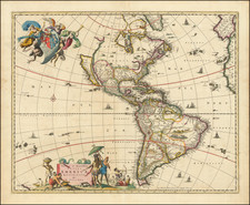
Rare example of the original Beaver Map, one of the most influential maps of North America published at the end of the 17th Century.
De Fer's wall map of America is one of the most important and well regarded maps of its time, incorporating late 17th Century Jesuit information from the Mississippi River and Great Lakes regions, as well as a massive depiction of California as an Island. The map is surrounded by images of natives and scenes from varying parts of the continents including two industries important to the old world, Beavers, for their pelts and the Newfoundland cod fishery. The two text panels describe the various regions including Louisiana, Florida and the English colonies.
The map is the first map to include a vignette of Beavers in Canada, which was later used by Herman Moll for his famous Beaver Map of the British Dominions in North America. According to Dahl, de Fer's map was engraved by van Loon, but the decorative vignettes were all designed, etched and engraved by Nicolas Guerard. The beaver scene shows dozens of industrious creatures against a backdrop of Niagara Falls, which Guerard most likely based on Hennepin's first printed view of the falls, published a year earlier in 1697. The first issue, from 1698, is extremely rare. Dahl calls it almost unknown; neither Tooley nor McLaughlin cite any edition prior to 1705. The present edition, is dated 1728 in the upper title block, with the name Guillaume Danet and 1739 in the lower center cartouche, with the name chez Benard. Jacques- Francois Benard, de Fer's son-in-law published thislater edition in 1739-40. The earlier date of 1713 appears at the bottom of the right text panel, unchanged from earlier editions.
While we were able to locate other references to Danet's involvement with this map, we have not located other references to the 1728 dating of this map and believe it to be a rare edition.
Nicholas de Fer (1646-1720) was the son of a map seller, Antoine de Fer, and grew to be one of the most well-known mapmakers in France in the seventeenth century. He was apprenticed at twelve years old to Louis Spirinx, an engraver. When his father died in 1673, Nicholas helped his mother run the business until 1687, when he became the sole proprietor.
His earliest known work is a map of the Canal of Languedoc in 1669, while some of his earliest engravings are in the revised edition of Methode pour Apprendre Facilement la Geographie (1685). In 1697, he published his first world atlas. Perhaps his most famous map is his wall map of America, published in 1698, with its celebrated beaver scene (engraved by Hendrick van Loon, designed by Nicolas Guerard). After his death in 1720, the business passed to his sons-in-law, Guillaume Danet and Jacques-Francois Benard.

![America noviter delineata [ Heightened with Gold Leaf ]](https://storage.googleapis.com/raremaps/img/small/71040.jpg)
![ПОЛИТИЧЕСКАЯ КАРТА ЮЖНОЙ АМЕРИКИ. [Political Map of South America]](https://storage.googleapis.com/raremaps/img/small/90259.jpg)