This item has been sold, but you can enter your email address to be notified if another example becomes available.


|
||

|

|
|

|
Stock# 30801
Description
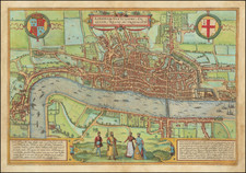
Fine detailed view of London, which identifies the Agas map of 1560 as its source.
A fantastic large decorative image, issued by Weller for the Weekly Dispatch Atlas.
The Agas map is the earliest surviving map of London. The map is attributed to Ralph Agas, but it is unlikely that Agas was in fact the maker. Only 3 examples are known to have survived. The original was 72 x 29 inches.
Whiled "dated" 1560, internal evidence (Old St. Paul's has lost its spire, the Royal Exchange is built, Northumberland House is not yet built) places the map between about 1570 and 1605.
![[ London - Chelsea ] An Accurate Survey of the Botanic Gardens at Chelsea with the Elevation and Ichnography of the Green House and Stoves, and an Explanation of the Several Parts of the Garden, shewing where the most conspicuous Trees and Plants are Disposed, the Whole Carefully Survey'd and Delineated by John Haynes](https://storage.googleapis.com/raremaps/img/small/85457.jpg)
![[ Area Around London ] Delineatio ac finitima Regio Magnae Brittaniae Metropoleos Londini ad novissimam Normam repraesentata et escusa a Matth. Seutter…](https://storage.googleapis.com/raremaps/img/small/103383.jpg)