|
||

|

|
|

|
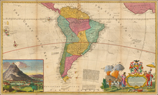
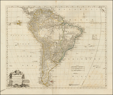
Scarce map of Peru, published by Mariano Felipe Paz Soldan, the first large format map of Peru.
The brothers Mateo and Mariano Paz Soldan were selected by Libertador y Gran Mariscal Ramon Castilla, the first stable leader of Peru, who came to power in 1845, to create the first official map of Peru. Mariano, the Minister of Public Works and a member of the Supreme Court, was an amateaur cartographer, who had published privately a new map of Peru. Castilla sought to update and improve upon the map in time for the Paris Exposition of 1864.
As noted by Michael Layland:
Paz Soldan devoted two years to the project. He travelled the capitals of Europe, obtaining and studying the accounts of the recent explorers. He commissioned artists and engravers in Paris. The six-sheet map measured four-and-a-half by almost seven feet. It was surrounded by a richly ornamented border depicting symbolic figures and images portraying Peru. He showed characteristic animals including the condor, puma, llama, tapir, jaguar and boa constrictor. Many typical plants were also there - maize, chincona(quinine), coca, rubber, banana, and the vanilla and strychnine vines. He even included some Amazonian butterflies. In a grave injustice to the guanay cormorant - the creature whose droppings had paid for all this lush artwork - he gave production credit to Humboldt's penguin. The map won a prize at the Exposition.