


|
||

|

|
|

|
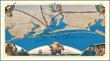
Separately issued chart extending from Texas, Florida and the Gulf of Mexico in the north to South America, pubished by R. H. Laurie in London.
Laurie's chart of the Gulf Coast region is one of the best large format charts published at the beginning of the 19th Century and surpasses the work of Arrowsmith in detail and accuracy. Unlike most sea charts of the period, there is a fair amount of interior detail given, especially along the major inland waterways of North America and in Central and South America.
Texas is referred to as the Province of Texas, which is shown as a part of Mexican Territory and the Gulf is also referred to as "Mexican Sea," showing that the map has been updated since Mexican Independence in 1821. The map also provides the course of the Gulf Stream and is filled with soundings an other off shore details. The Gulf Stream details include information on the significance of the location of "Gulf Weed" within the Gulf Stream and on either side thereof.
The detail along Florida and the Gulf Coast is exceptional, with light houses and dozens of early placenames. Within the United States, the interior of the chart includes dozens of towns, forts, settlements and Indian Villages, along with the major post roads.
Earlier editions of this chart appeared in Laurie & Whittle's West India Atlas. Other editions noted include 1813 and 1818. All editions are quite rare and we have not located another example of this edition of the map. We have not been able to locate another example of any edition of the map on the market in the past 30 years.
Richard Holmes Laurie (1777-1858) was the son of mezzotint engraver Robert Laurie, who had taken over Robert Sayer's publishing house with James Whittle in 1794. Richard Holmes Laurie joined in a partnership with Whittle when his father retired in 1812. The name of the firm then switched from Laurie & Whittle to Whittle & Laurie. Whittle died in 1818, leaving Richard Holmes to continue publishing alone as R. H. Laurie.
When the Hydrographic Office opened in 1795, it was tasked with creating and producing all the nautical charts for the Royal Navy so as to wean the Navy off dependence on foreign charts. By the 1820s, private publishers were augmenting HO charts and competing with them, including Richard Holmes Laurie. Richard gave up publishing anything except nautical materials by 1830. He also sold charts to Trinity House, the lighthouse and maritime safety fraternity. He died in 1858.
The firm continued to print under the name R.H. Laurie even after 1858. Later, the firm was managed by Laurie’s draughtsman, Alexander George Findlay, and, later, Daniel and William Kettle.
![[Central America]](https://storage.googleapis.com/raremaps/img/small/77960.jpg)
![Carte De La Louisiane Et Du Cours Du Mississipi . . . Juin 1718 [1st State!]](https://storage.googleapis.com/raremaps/img/small/59797.jpg)
![[Matagorda Bay] Bahia De S. Bernardo](https://storage.googleapis.com/raremaps/img/small/54374.jpg)