|
||

|

|
|

|
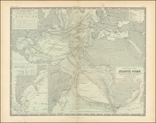
Striking double hemisphere map of the World, exhibiting the discoveries of Captain James Cook on his 3 voyages of discovery to the Pacific, including his final demise in the Sandwich Islands (Hawaii).
This remarkable map, originally published by De Vaugondy in 1752 and here updated with significant revisions and updates, including the tracks of major explorers, including Captain Cook, Furneaux and other navigators, primarily in the Pacific Ocean, but with additional details throughout the Indian Ocean and Atlantic Ocean.
De Vaugondy's original map was largely devoid of explorer's routes and included no information north of California and the Straits of Anian. In addition, much of the western half of Australia was completely unknown and shown in the conjectural style popularized in the first half of the 18th Century. In this revised edition, the Northwest Coast of America is now shown in great detail, albeit very inaccurately so, adopting the De L'Isle model of the region, repleat with hopeful watercourse from the Pacific to the Atlantic and a western extension of the Coast of North America which extend more than 20 degrees west of its true location. Curiously, the Aleutian Islands appear, but are in a virtually unrecognizable form.
In Australia, the results of Cook's explorations along the west coast are in evidence, as is an updated New Zealand and early appearance of Hawaii. The Terres Antarcticque are named, but no with only a hint of a speculative landmass.
Gilles Robert de Vaugondy (1688-1766) and Didier Robert de Vaugondy (1723-1786) were influential figures in the realm of 18th-century French cartography. Originating from Paris, their contributions to mapmaking were significant during an era of expansive geographical exploration.
Gilles Robert de Vaugondy entered the world of cartography not through family tradition but through personal interest and the budding opportunities of his time. Born in 1688, he worked during a time when Paris was becoming a central hub for cartographic activities. Gilles often incorporated the latest findings from explorers into his maps, making them sought-after for their contemporary relevance. His connections weren't limited to his immediate circle; he frequently interacted with other key mapmakers, staying updated on the latest techniques and findings.
His son, Didier, was born in 1723 and had the advantage of growing up surrounded by maps and globes. While his father was renowned for maps, Didier made a name for himself in the field of globemaking. His globes were some of the most precise and detailed in France, gaining recognition even among the royalty. In addition to his work in cartography and globemaking, Didier had a keen interest in education, especially after the expulsion of the Jesuits from France. He stepped in to produce geographical educational materials, fulfilling a newfound need.
The maps and globes produced by the Vaugondys remain an enduring testament to the peak of French cartography during the Enlightenment. Their works, characterized by precision and the inclusion of contemporary findings, helped to shape our understanding of the world during a transformative period in European history.
![[Olivier van Noort Portrait / World Map]](https://storage.googleapis.com/raremaps/img/small/79567.jpg)
![Ленин – вождь международного пролетариата [Lenin – Leader of the International Proletariat]](https://storage.googleapis.com/raremaps/img/small/93242.jpg)