
This item has been sold, but you can enter your email address to be notified if another example becomes available.


|
||

|

|
|

|
Stock# 30587
Description
Detailed large format map of Maui, including extensive geographical and topographical details.
One of the most detailed maps of the Island of Maui published in the 19th Century. Shws the lands in the public domain, lands reserved for Kamehameha III for his private use in the Great Division of 1848 and Government lands.
The Crown lands are colored in Yellow. Government lands are colored in Green.
The names of landowers and grant information are shown, along with topographical details, early roads nad other details. A modest town plan is shown for Lahaina.
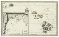
![[Early Hand Drawn Map of the Hawaiian Islands]](https://storage.googleapis.com/raremaps/img/small/62429.jpg)
![Wailuku [Maui]](https://storage.googleapis.com/raremaps/img/small/61147.jpg)