
This item has been sold, but you can enter your email address to be notified if another example becomes available.


|
||

|

|
|

|
Stock# 30466
Description
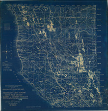
Interesting large format topographical map centered on the Santaa Ana River, published by the United States Geological Survey.
The map extends from Santa Ana to Aliso Point, showing a number of Ranchos, including Santiago de Santa Ana, Loma de Santiago, and Las Bolsas. Includes early railroad lines, topogrphical details, towns, rivers, etc. One of the earliest detailed and reasonably obtainable maps of the region.
![[Part of Orange County] Anaheim Quadrangle](https://storage.googleapis.com/raremaps/img/small/83489.jpg)

![Rand McNally Standard Map of California [2 sheets]](https://storage.googleapis.com/raremaps/img/small/84794.jpg)