|
||

|

|
|

|
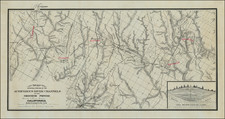
Scare irrigation district and road map of the Imperial Valley, with a tract map on the verso.
One side of the map is an "Irrigation District and Road Map, Imperial Valley, published by A.G. Thurston, El Centro and Pasadena." On the verso is "Imperial Valley Tract Map, Best Edition, published by A.G. Thurston, El Centro and Pasadena.'' On the verso is Both maps "drawn by Geo. H. Rock." We previously offered an 1912 edition of the same map.
The changes to the two maps are noticeable, even in the 2 year period. E .A. Allen is now the real estate specialist listed, rather than the Imperial Valley Syndicate.
The townsite for Calipatria is shown in manuscript. A mast head above the Irrigation map provides Facts About Imperial Valley, Imperial County, Cal. Perhaps the best fact being:
Telephone Connection in and out of the Valley is unusually good for a new system, and a large sum of money is now being expended to make the system the best.
Link to the 1912 edition: /gallery/detail/21610
Fascinating early look at the Imperial Valley and its then existing water distribution and irrigation systems, which would allow the region to become a booming agricultural region. Perhaps most notable are the wide channels of the New River and Alamo River, draining the Salton Sea from its southern edge toward Mexico.
![(California Environmental Law) Storage Reservoirs For Hydraulic Mining Debris -- American, Yuba and Bear Rivers, California [Report of the Hydraulic Mining Commission Upon The Feasibility of the Resumption of Hydraulic Mining in California]](https://storage.googleapis.com/raremaps/img/small/63497.jpg)