This item has been sold, but you can enter your email address to be notified if another example becomes available.


|
||

|

|
|

|
Stock# 30003
Description
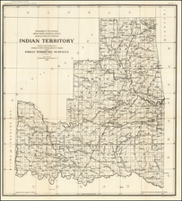
Scare early survey of the Cherokee Lands in Indian Territory, trajcking te North Fork of the Canadian River, the Red Fork and Salt Fork of the Arkansas River, Verdigris River and the Neosho River.
Ft. Gibson and Ft. Smith are shown, along with Union Mission and several Indian Villages, incluiding White Hair Village on the Osage Reservation, Osage Village.
One of the earliest obtainable maps of the region, showing the the earliest surveys undertaken by the US Government.
Condition Description
Minor repair at bottom left, with loss of neat line.
Reference
Clausen & Friis #188.