This item has been sold, but you can enter your email address to be notified if another example becomes available.


|
||

|

|
|

|
Stock# 29933
Description
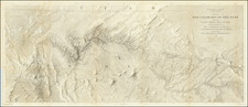
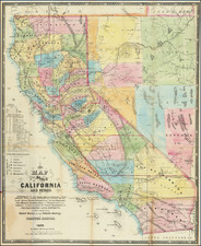
Detailed map of the Central part of Los Angeles, prepared by the Southern Pacific Railway and showing a roughly 5 miles radius around the Downtown Freight Depot and other SPRR properties near the Los Angeles River.
The map provides a fantastic large format look at Downtown Los Angeles, showing the Downtown Court House, Railroad Lines and Depots, County Hospital Grounds, East Side (Lincoln) Park, Prospect Park, Hollenbeck Park, Evergreen Cemetery, Sisters Hospital, an unnamed downtown Cemetery at Hill and Grand (now the location of Central High School and the Board of Education Building), Calvary Cemetery and Elysian Park
Condition Description
Printed on Waxed Linen. Minor Soiling.