|
||

|

|
|

|
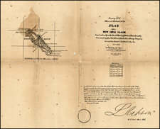
Rare early map of Redlands, California, traced by theSouthern Pacific Railroad Company from an original map prepared by Isaac Ford and printed by Britton & Rey in San Francisco.
The map is an early 20th Century tracing map, likely prepared to provide the location of several Franchises granted by the Southern Pacific Railroad to C.S. Chestnut and to George H. Dunn in January 1907. Franchises were rights granted to utilize lands within the railroad right of way, typically to operate street car lines. The following note appeared in a 1908 edition of Electric Traction Weekly:
ANOTHER LINE FOR REDLANDS, CAL.
C. S. Chesnut and George H. Dunn of Redlands, promotors of the proposed line from Redlands to Yucaipa Valley and Oak Glenn state that while the construction of the road has been delayed by the financial flurry, they have the assurance that they will be able to commence work early in the spring.
The original Ford map is likely the first printed map of Redlands, published only 2 years after its incorporation. A link to the map can be seen here: /gallery/detail/29881
![[ San Francisco Bay, North Coast & Monterey Bay Region ] Amer. Sep. No. 46 Nouvelle Californie](https://storage.googleapis.com/raremaps/img/small/98751.jpg)
![(California Gold Rush) Oregon and California in 1848 in Two Volumes [with:] Map of California, Oregon, Texas, and the Territories adjoining with Routes &c.](https://storage.googleapis.com/raremaps/img/small/82901.jpg)