


|
||

|

|
|

|
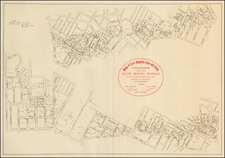
Very early blueprint map of Imperial County, prepared for the Southern Pacific Railroad, including early annotations showing the Company's plans for lines near the existing line from east of the Salton Sea to Glamis, with some additional annotations above the X in Mexico.
The map is signed by E.H. Gaines as County Surveyor and includes the signatures of each of the County Surveyors. Prepared only months after the creation of Imperial County, it is quite drawn from the earliest manuscript map of the County.
OCLC shows the earliest printed map of Imperial County as being the the C.N. Perry map of 1909 (Perry was the County Surveyor). The present map is on a substantially larger scale than the Perry map. The map was deaccessioned by the Southern Pacific in the mid-1980s.
Imperial County was formed in 1907 from the eastern portion of San Diego County. The county took its name from Imperial Valley, itself named for the Imperial Land Company, a subsidiary of the California Development Company, which at the turn of the 20th century had claimed the southern portion of the Colorado desert for agriculture. Much of the Imperial Land Company's land also existed in Mexico (Baja California). The objective of the company was commercial crop farming development.
By 1910, the land company had managed to settle and develop thousands of farms on both sides of the border. But the Mexican Revolution severely disrupted the company's plans. Nearly 10,000 farmers and their families in Mexico were ethnically cleansed by the rival Mexican armies.

![[San Diego County Before Orange, Riverside and Imperial Counties] Sketch Map of San Diego County Showing the Position of Mines and Minerals Referred to in the 6th Annual Report of the State Mineralogist of California . . . .1886](https://storage.googleapis.com/raremaps/img/small/104557.jpg)