|
||

|

|
|

|
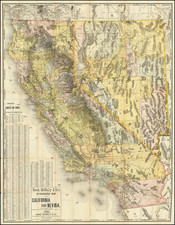
Rare (and possibly unique) example of this separately issued map of the West, Texas and Mexico, issued by Julius Hutawa in St. Louis, which shows the original outline color employed by Hutawa in 1847-1848.
The original 1847-1848 editions of the map were surprisingly accurate as regards internal details and the many routes, among which are those of Smith, Gregg, Kearny, Cooke, Fremont, Lewis and Clark, and others. The trails, including the Oregon, Old Spanish, and Santa Fe are laid down, as are the forts, the trading posts, and the locations of the various Indian tribes. This edition of the map continues to show a massive Texas, pre-dating the 1850 Compromise and pushing Texas east to the Mississippi River.
The map is also remarkably accurate for its detail in New Mexico, showing towns, settlements, mines and other fine details.
According to Howell, " Hutawa published the first edition of this map in 1847, although according to Wheat no copy has ever been located."
In 1863, Hutawa's revised the boundaries to reflect the Territories of the Western US as of 1853, including Washington Territory, Oregon, Nebraska Territory, Utah Territory, Kansas Territory, Indian Territory, New Mexico Territory and the state of Texas, based upon the Compromise of 1850. It would seem almost certain that the revision was originally done in 1853, but there are no extant copies of the map dated 1853.
The present example of the map may be the first example of the map with the early (pre-1863 edition) boundaries to appear on the market since John Howell offered the Streeter copy of the map for sale in 1980. We surmise that the present example of the map is an early proof state of the 1863, pre-dating the change in the boundaries and before the addition of the words "New Mexico".
It is believed that Hutawa first issued this map in 1847 (undated), in response to the demand for information relating to Mexico, with the outset of the Mexican-American War. The map was thereafter utilized to meet the growing demand for overland maps to the gold regions of the California Gold Rush and the West. There is no surviving example of the first edition. A second edition was issued in 1848, at least 2 later editions dated 1863. Wheat describes 4 editions including the first, for which there are no surviving examples. Streeter's sale included a third and fourth edition, both dated 1863. He identified the earlier edition as having a pre-Gadsden purchase boundary with Mexico and the later edition has having "New Mexico" stamped onto the map. Curiously, Streeter makes no mention of the oversized Texas or other earlier boundaries, leading us to believe that this map could in fact pre-date the earlier of the Streeter copies.
The Streeter entries for the map rely entirely upon Wheat for identification. Wheat's description of the map is somewhat convoluted and we suspect Wheat may not have seen this edition of the map.
While the 1863 edition with the Western Territorial boundaries appears on the market occasionally, this is the only example of the map with the early borders we have ever seen on the market.
![[Coastal Orange County] Santa Ana Quadrangle](https://storage.googleapis.com/raremaps/img/small/83561.jpg)

![The Mines of Colorado [with:] Map of Colorado Territory to accompany Hollisters](https://storage.googleapis.com/raremaps/img/small/100860.jpg)