|
||

|

|
|

|
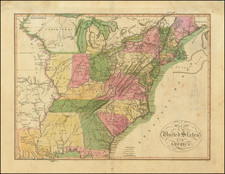
Rare map of the United States, depicted shortly after the Louisiana purchase.
An outstanding western map, providing interesting detail on both sides of the Misssissippi River. A massive Indiana Territory takes up the old Northwest Territory. An oddly shaped Ohio appears below Indiana Territory, primarily in modern Illinois.Mississippi Territory includes Alabama and is full of Indian villages and forts.
Western Tennessee and Kentucky are sparsely populated and include several forts. Several conjectural mountain ranges dominate the Plains, along with forts and Indian Villages. Nice detail inTexas. The source of the Mississippi & Missouri Rivers reflects the map's predating Lewis & Clark and Humboldt.
A scarce and desireable map, one of the earliest maps of the US published after the Louisiana Purchase.
![Karte von Tejas und den angrenzenden Theilen Mejicos . . . [with California Gold Regions Inset]](https://storage.googleapis.com/raremaps/img/small/61669.jpg)
![The Rise, Progress and Prospects of the Republic of Texas [including:] Map of Texas, compiled from Surveys recorded in the Land Office of Texas, and other Official Surveys, By John Arrowsmith. [and:] A Map of the Republic of Texas and the Adjacent Territories, Indicating the Grants of Land Conceded under the Empresario System of Mexico.](https://storage.googleapis.com/raremaps/img/small/94046.jpg)
![[The First Maps Printed Color] Cartes en Couleur des Lieux Sujets aux tremblements de Terre Dans toutes les parties du Monde Selon le Sisteme de l’impulsion Solaire](https://storage.googleapis.com/raremaps/img/small/52293op.jpg)
![[First State of the Popple Key Sheet] A Map of the British Empire in America with the French and Spanish Settlements adjacent thereto by Hen. Popple.](https://storage.googleapis.com/raremaps/img/small/92714.jpg)