|
||

|

|
|

|
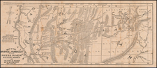
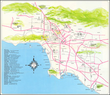
Unique map of Rancho Palos Verdes, which has been modified to show the Palos Verdes proposal in 1925 for the future campus of UCLA.
The base map is Charles Cheney's original master subdivision map for Rancho Palos Verdes, prepared in 1923, which has been modified for the proposal to the UC Regents.
In 1919, a syndicate led by Irving Hellman acquired an option to purchase the entire Palos Verdes Peninsula for $ 3,200.000. His plans were to drill for oil and then to subdivide the balance of the land for home sites. These plans were later abandoned.
In 1921, a real estate developer named E.G. Lewis acquired the Palos Verdes Project, which would constitute the future City of Palos Verdes Estates and part of the Miraleste area of the current day City of Rancho Palos Verdes. The community was called Palos Verdes Estates and had decreased in development area by one-fifth, from the original 16,000 acres to 3225 acres. Ninety percent of the development was zoned for single-family residential architecture.
The Master Plan for the community had been originally drafted by Charles Cheney of the architectural firm Olmsted Brothers. The Olmsted Brothers were also employed to landscape the development. The Olmsted Brothers also designed the street layout of Palos Verdes Estates as well as that of the city of Torrance. Planning for the Project included all aspects including the street system, zoning, lot sizes, and planned landscaping.
Cheney was the second most important man, next to Frederick Law Olmsted, Jr., on the team. Cheney arrived on the scene about 1921, brought by the then-developer Edward G. Lewis, with whom he developed a scheme for a City Beautiful at Atascadero (San Luis Obispo County, California, 1913). Cheney was a leader in city planning, Director of the National Conference on City Planning, and had experience in California at places such as Riverside, Santa Barbara, Long Beach, Los Angeles, and Berkeley.
A section of 1,000 acres was originally set aside by the planners of the Palos Verdes Project for a University campus. In November 1921, even before Mr. Lewis had acquired the Palos Verdes Project, a proposal was made for the relocation of the southern branch of the University of California (which later was renamed UCLA), which was then located on Vermont Ave. in Los Angeles . The proposed site was in the center of the Palos Verdes Peninsula where Peninsula High School, the Peninsula Shopping Center, and the Avenue of the Peninsula Shopping Center is located.
The proposal, in addition to the donated 1,000 acres, included other inducements. These inducements included $1,000,000, the construction of a model grammar school and a model high school to be run by the University's Department of Education, a marine biological station and public aquarium, an art museum, a theatre seating 1,500, a boathouse at Portuguese Bend and a football stadium to seat 140,000.
![[Eastern San Diego County] Cuyamaca Quadrangle](https://storage.googleapis.com/raremaps/img/small/83422.jpg)