|
||

|

|
|

|
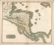
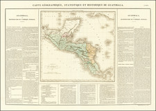
Nice example of this important early map of Panama, published during the period when it was still one of the states of Colombia, one of the earliest printed maps of Panama based upon indigenous surveys.
Manuel María Paz Delgado (1820-1902) was a officer in the Colombia army, mapmaker and artist. In 1853 he entered the Chorographic Commission to participate as a draftsman with Henry Price, who for reasons of poor health had to retire later in the same year. Between 1853 and 1858, Maria Paz worked with Cordazzi, perhaps the most famous map maker of the northern part of South America after its independence from Spain.
With Codazzi's death in 1859, the work of the Commission was stopped. Maria Paz and Manuel Ponce de Leon were given control of the project's completion and publication of the surveying and mapping work performed under the general direction of Codazzi. The work resulted in the the publication of the atlas of the United States of Colombia in 1865, the first indigenous atlas of Colombia.
Panama first asserted its independence in 1841. In November 1840, the isthmus under the leadership General Tomás Herrera, who assumed the title of Superior Civil Chief, declared its independence. The State of Panama took the name of 'Estado Libre del Istmo', or the Free State of the Isthmus in March 1841. By the time the civil conflict ended and the government of New Granada and the government of the Isthmus had negotiated the Isthmus's reincorporation to the union, Panama's First Republic had been free for 13 months. Reunification happened on December 31, 1841.
Under Colombia's federalist constitution that was later adopted in 1858 (and another one in 1863), Panama and other constituent states gained almost complete autonomy on many levels of their administration, which led to an often anarchic national state of affairs that lasted roughly until Colombia's return to centralism in 1886, with the establishment of a new Republic of Colombia. Full independence was not achieved until 1903.
![[Fruit Crate Label Advertising Map] Panama Brand (North America & Panama Canal)](https://storage.googleapis.com/raremaps/img/small/48860.jpg)