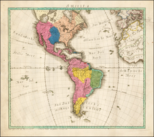
|
||

|

|
|

|
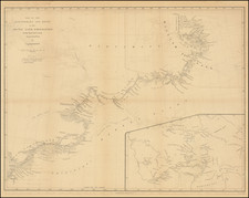
Rare map of the Canadian Arctic Regions, published by George Philip & Son in Liverpool, one of the earliest maps to depict MacClure's discovery of the Northwest Passage in 1854.
Philip's map is one of the most up to date maps of the region from the period and among the rarest. It is of perhaps greatest note for being one of the first maps to depict MacClure's route in discovery of the Northwest Passage in 1854.
In addition to the discoveries of Edward Belcher in 1852 and MacClure in 1854, during his expedition in search of Sir John Franklin, the tracks of the Investigator are shown (1851), along with the H.M.S. Phoenix (1853).
The H.M.S. Phoenix a 6-gun steam paddle vessel of the Royal Navy, built in 1832 and ultimately refitted for Arctic service under Captain Edward Inglefield in February 1853. The Phoenix was used to supply Sir Edward Belcher's expedition at Beechey Island. Inglefield carried the news of the discovery of the North-West passage by Robert McClure back to England in October 1853. Inglefield remained in command when she recommissioned at Woolwich on 21 February 1854, and she returned to Beechey Island to re-supply Belcher. Inglefield brought home the ship's company of HMS Investigator, which had become trapped in the ice.
The map also shows the routes of Captain Ross in 1818 and Captain Parry in 1820. The map includes insets of Russian America and Capt. Franklin's journey from Coppermine River to the head of Bathurst Inlet and return by Hood's River.
The map is extremely rare. OCLC notes only the copies in the British Library and University of Chicago. The only example which has been offered for sale at auction or in a dealer catalogue (per AMPR and Americana Exchange) was offered for sale by Edward J. Lefkowicz in 2000 (with minor restoration).
![[North Polar Calotte from a 17th Century Dutch Globe]](https://storage.googleapis.com/raremaps/img/small/70704.jpg)
![Colton's Map of the United States The Canadas &c. Showing the Railroads, Canals, & Stage Roads With Distances From Place to Place…1856 [Pocket Map]](https://storage.googleapis.com/raremaps/img/small/85342.jpg)