The item illustrated and described below is sold, but we
have another example in stock. To view the example which
is currently being offered for sale, click the
"View Details" button below.
1777 circa Tobias Conrad Lotter
$ 1,100.00


|
||

|

|
|

|
Stock# 29409
Description
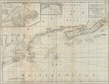
Detailed map of Long Island, the Colony of Connecticut and part of Rhode Island and Massachusetts, one of four sheets from the Lotter edition of Jefferys map of New England.
The map includes all English nomenclature and names counties, towns, rivers, lakes, bays, and a host of other details. Nice early illustration of the roads in the colonies, especially on Long Island.
Condition Description
1 sheet of Lotter's 4 sheet map of New England. Minor foxing.
Tobias Conrad Lotter Biography
Tobias Conrad Lotter (1717-1777) is one of the best-known German mapmakers of the eighteenth century. He engraved many of the maps published by Matthaus Seutter, to whose daughter Lotter was married. He took over Seutter’s business in 1756. Lotter’s son, M. A. Lotter, succeeded his father in the business.

![Map of the States of Massachusetts, Connecticut and Rhode Island [Large Boston Inset]](https://storage.googleapis.com/raremaps/img/small/91825.jpg)