


|
||

|

|
|

|
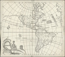
Striking double hemisphere map of the World, with allegorical vignettes of the continents in the corners and 10 astronomical diagrams in panels at sides.
The map was issued shortly after the final voyage of Captain James Cook and shows the tracks of Cook's 3 Voyages, along with several other voyages. Hawaii appears on the map for the first time, having been added along with a still quite fanciful view of the Northwest Coast of America, although the Bay of the West is no longer shown.
Australia and New Zealand reflect updated coastlines, although the shape of New Zeland's 2 islands is quite odd and Austraila is truncated at the east, with what appears to be a small part of its northeastern coastline shown to the west of New Caledonia in the Western Hemisphere.
The map is dated Ans 3, which is the third year of the French Revolution.
Jean-Baptiste Nolin (ca. 1657-1708) was a French engraver who worked at the turn of the eighteenth century. Initially trained by Francois de Poilly, his artistic skills caught the eye of Vincenzo Coronelli when the latter was working in France. Coronelli encouraged the young Nolin to engrave his own maps, which he began to do.
Whereas Nolin was a skilled engraver, he was not an original geographer. He also had a flair for business, adopting monikers like the Geographer to the Duke of Orelans and Engerver to King XIV. He, like many of his contemporaries, borrowed liberally from existing maps. In Nolin’s case, he depended especially on the works of Coronelli and Jean-Nicholas de Tralage, the Sieur de Tillemon. This practice eventually caught Nolin in one of the largest geography scandals of the eighteenth century.
In 1700, Nolin published a large world map which was seen by Claude Delisle, father of the premier mapmaker of his age, Guillaume Delisle. Claude recognized Nolin’s map as being based in part on his son’s work. Guillaume had been working on a manuscript globe for Louis Boucherat, the chancellor of France, with exclusive information about the shape of California and the mouth of the Mississippi River. This information was printed on Nolin’s map. The court ruled in the Delisles’ favor after six years. Nolin had to stop producing that map, but he continued to make others.
Calling Nolin a plagiarist is unfair, as he was engaged in a practice that practically every geographer adopted at the time. Sources were few and copyright laws weak or nonexistent. Nolin’s maps are engraved with considerable skill and are aesthetically engaging.
Nolin’s son, also Jean-Baptiste (1686-1762), continued his father’s business.
Louis Denis (1725-1794) was a French geographer and cartographer best known for his incomplete road atlas of France, Le Conducteur français. Originally trained as an engraver, he partnered with Louis-Charles Desnos to create and edit maps. Later, Denis served as geography tutor to the children of the French royal family. His pupils included the Duc de Berry, the future Louis XVI.
![[ Phases of the Moon ] Phasis Lunae Gibberosae Crescentis, observata Solnoci Anno MDCXCVI die 9 Augusti hor. 10 pomer. [and] Phasis Lunae Adulta, observata Segedini Anno MDCXCVI. Die 11 Iulii, intra hor 10 et 11. pom](https://storage.googleapis.com/raremaps/img/small/95540.jpg)
![[From the Library of Captain Louis Freycinet] Carte Hydrographique Des Partes Connues De La Terre Dressee sur la Projection de Mercator, Poar C.LO. Gressier , Ingenieur Hydrographe de la Marine . . . 1835 (with extensive manuscript annotations)](https://storage.googleapis.com/raremaps/img/small/58604.jpg)
![[ Corvus ]](https://storage.googleapis.com/raremaps/img/small/68933.jpg)