


|
||

|

|
|

|
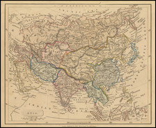
Fine old color example of Allard's map of Asia and the Northern part of Australia, called Hollandia Nova.
Extends North to the unknown coasts of Yesso. Interesting projection of Japan. Nice detail in China, including naming Formosa. Several place names on the Northern Australian Coast. Nice detail in Southeast Asia.
The information on this region was taken from Nicolas Witsen's 6-sheet map of Tartary from 1687 as noted above the bottom border. Witsen gathered much of this information from the governor of Tobolsk, and formulated a completely new interpretation of the northeast extremity of the continent, shown here in an inset. It shows a long mountainous peninsula, Ys Caap (Icy Cape), which was believed to render it impossible to sail around northern Asia to reach the wealth of the East Indies.
Witsen's influential map became the standard model for the mapping of Asia until the expeditions of Bering (1725-1749). The rest of the map draws mainly on De Wit's maps of Asia, except that Allard presents a completely different, and apparently unique, configuration of the Black and Caspian Seas.
Carel (Carol) Allard (Allardt) (1648–1709) was an engraver and publisher based in Amsterdam. Part of a prominent family of Dutch mapmakers, publishers, and print sellers, his father was engraver and publisher Hugo Allard (1627–1684), who left his business to Carel upon his death. Carel published anything in demand, including maps, topography, ethnography, newsprints, and restrikes of old plates of artistic prints, many of which likely came from his father’s stock. In 1706, Carel gave his copperplates to his son Abraham Allard, before going bankrupt.
![[ World & Continents ] Typus Orbis Terrarum / Americae Sive Novi Orbis Nova Descriptio / Asiae Nova Descriptio / Africae Tabula Nova / Europae](https://storage.googleapis.com/raremaps/img/small/99250.jpg)

![(Rare Czech Edition!) [Asia Secunda Pars Terrae in Forma Pegasi] [Asia in the Form of Pegasus]](https://storage.googleapis.com/raremaps/img/small/95830.jpg)