|
||

|

|
|

|
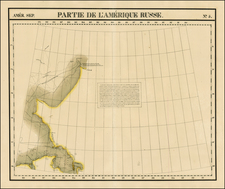
This is the first revision of the Muller/De L'Isle Chart which does away with the Bay of the West and adds in the results of the discoveries along the NW Coast by Cook et al. Despite the updated coastline and sighting of Mt. St. Elias, the map retains notes regarding the discoveries of Juan De Fuca in 1592 and Martin d'Aguilar in 1503, as well as Drake's discoveries in 1578 and the landfall at Cape Fortune in 1542. The map also notes the landfalls of Captain Tschirikow in 1741 and Captain Bering in 1741, alont with their routes across the Atlantic. The River of the West remains as a speculative southern route to the Atlantic, along with a wide open Northwest Passage above Baffin's Bay. Cartography of the West Coast extends south to Southern California (San Pedro & Channel Islands). Unlike the Muller chart, which was reproduced many times during its lifetime, this updated map is relatively scarce. A nice example with full wide margins. See, Wagner 633, Portinaro CLV and Kershaw IV, #1146.


![[ Alaska ] U.S. Coast Survey — Explorations in Alaska By the Party under the direction of WH. Dall, Assistant. 1874](https://storage.googleapis.com/raremaps/img/small/96642.jpg)

![[Alaska to San Diego and San Qunitin, British Columbia] A Chart Shewing Part of the Coast of N.W. America, with the Tracks of His Majesty's Sloop Discovery and Armed Tender Chatham . . . (First Modern Map of the West Coast of North America)](https://storage.googleapis.com/raremaps/img/small/102067.jpg)