The item illustrated and described below is sold, but we
have another example in stock. To view the example which
is currently being offered for sale, click the
"View Details" button below.


|
||

|

|
|

|
Stock# 2879
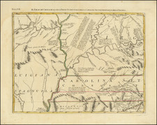
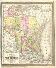
Description
Wonderful early map of Wisconsin, hand colored by county and showing townships, towns, rivers, Indian details, Lakes, Forts and other information. Many of the Northern and Western Counties have not yet been formed, nor are the State township surveys completed. Narrow right margin, with very minor loss at the lower right corner, else an excellent example. But for the loss of the outer neatline, this would be a $200.00 map.