|
||

|

|
|

|
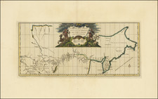
Important early map of the explorations in search of the Northeast Passage, engraved by Johannes & Baptista à Doeticum for Linschoten's " Voyagie, ofte schip-vaert, van Ian Huyghen van Linschoten, van by Noorden om langes Noorvvegen de Noortcaep, Laplant, Vinlant, Ruslandt, de VVitte Zee, de custen van candenoes, Svvetenoes, Pitzora. . . first published in Amsterdam in 1601.
The map illustrates the account of Willem Barentsz's first attempt to find the Northeast Passage to the Pacific, via the Arctic Seas above Russia in 1594, written from Linschoten's own experiences as a crew member. On the mainland of "Nova Hollandia" is "Linschotens hoeck" (headland); it was customary for features discovered from ships to be named after the spotter.
Orientated with north to the bottom, the chart is centered on Vaygach Island, with the Barents Sea on the right and the Kara Sea on the left. Titles, in Latin and Dutch, are within strapwork cartouches, across the seas are two finely-engraved compass roses, whales, walruses and galleons; over the land are five coats of arms.
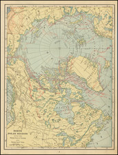
![[Untitled Map of the Northern Hemisphere]](https://storage.googleapis.com/raremaps/img/small/18651.jpg)