This item has been sold, but you can enter your email address to be notified if another example becomes available.


|
||

|

|
|

|
Stock# 28590
Description
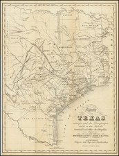
One of earliest printed maps of Dallas.
The present map is one of the earliest obtainable separately issued maps of Dallas.
The map marks in red 8 city lots near the corner of Ervay Street, Main Street and Commerce Street, at the center of the map.
There appear to be two editions of the map. The other edition notes that it was included in a Dallas Almanac.
OCLC notes only the following maps which are earlier than the present map: (1) Jones & Murphy's map of the city of Dallas, Texas (1878) and (2) Murphy and Bolanz' Official map of the city of Dallas (1887, 1888 and 1891 editions). The Library of Congress has only one map in its on-line collection which predates this map. Phillips and Day do not list any maps of Dallas from before 1900.
Condition Description
Flattened and laid on archival paper, to support thin spots. etc.
![(Texas Photograph) [Cabinet Card Birdseye View of El Paso, Texas and Ciudad Juarez]](https://storage.googleapis.com/raremaps/img/small/92983.jpg)

![[ Texas Oil Map ] Map of Terrell County Texas](https://storage.googleapis.com/raremaps/img/small/102589.jpg)