|
||

|

|
|

|
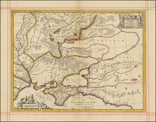
Fascinating map locating the Kungur Ice Cave in the Ural Mountains in Russia.
The Kungur Ice Cave is located on the right bank of the Sylva River. In 1703 Peter the Great issued the decree sending a well-known geographer, S.U. Remezov from Tobolsk in Kungur. He worked out the Uyezd plan and the first sketch of the Cave. Remezov's plan was distributed throughout Europe in scientific journals of the time.
Kungur was founded 11 miles north of the Iren River's mouth on the banks of the Kungurka River in 1648. In 1662, it was burned by Bashkirs. In 1663, it was rebuilt as a fortress on the place of Mysovskoye village. In the beginning of the 18th century, leather and footwear industries started to develop here, and in 1724, a tannery was built.
By the mid-18th century, Kungur became one of the most populated areas in the Urals. In 1759, Perm administration of mining plants was moved to Kungur. By the end of the 18th century, Kungur is an important transit trade center of the Siberian road, as well as the center of leather manufacture in Perm province. Kungur rope and linseed oil were widely known. In 1774, the town withstood a siege by Yemelyan Pugachev's Cossack forces.
![Livoniae Provinciae Ac Eivs [with] Moscoviae Maximi Amplissimi Que Ducatus](https://storage.googleapis.com/raremaps/img/small/65792.jpg)
![Drink Norden Kaffe [Russia]](https://storage.googleapis.com/raremaps/img/small/91603.jpg)