


|
||

|

|
|

|
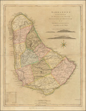
Fine full color example of Thomas Jefferys' map of Barbadoes, from The West-India Atlas.
This large-scale map is based on William Mayo's important survey of the island. Mayo conducted the first large-scale survey of the island, fixing the legal descriptions of the parishes. It was not until the Admiralty survey of 1873 that Mayo's map ceased to be the standard representation for maps of Barbados.
The map shows the eleven parishes with their areas listed in a key below. It depicts the ports, settlements, forts, churches, roads, and sugar plantations with landowners' names. Relief is shown by hachures and two finely drawn landfall approach views for mariners are engraved between the title and compass rose.
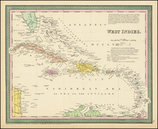
In describing the West India Atlas, Rumsey notes:
This is a superb atlas of the West Indies and a companion atlas to Jeffery's American Atlas also first issued in 1775. The latest date on the charts in this copy is 1788 (The Cape Verd Islands). . . . Jefferys died in 1771; Sayer and Bennet acquired his materials in preparation for this atlas, and published the atlas posthumously under his name (as they did with the American Atlas) in 1775. The heart of this atlas and the most detailed part is the sixteen sheet large chart and index sheet of the whole of the West Indies. The rest of the atlas consists of charts of the Atlantic Islands and the British Channel, as well as individual maps and charts of seventeen islands in the West Indies. . . . Phillips shows issues of 1775, 1781, 1787, 1794, 1796, 1807, and 1818. With the 1794 and later editions, 20 maps are added of various additional islands. Sayer and Bennet also published in 1775 a smaller version of this atlas called "The West India Islands: From Actual Survey and Observations..." that consisted of the same text, a general chart of the Islands, and the same sixteen or seventeen (depending on the edition) charts of the islands that appear in the larger version (P3942). Finally, Jefferys himself published in 1762 "A Description of the Spanish Islands and Settlements on the Coast of the West Indies" which was issued in quarto, with a general chart and 32 maps and plans of harbors and towns . . .
William Mayo was born in Poulshot, Wilts County in southwestern England in 1684.
In 1709, Mayo and his brother Joseph moved to Barbadoes, where a cousin had settled some time earlier. There he established himself as a surveyor, and in due course married the daughter of a Bridgetown merchant. In 1717 Mayo received a commission to make a map of Barbadoes, which he accomplished with such skill that Governor William Tryon urged the English Board of Trade to purchase it and to grant Mayo a patent enabling him to sell his map on a commission basis. The map also gained him election to membership in the Royal Society of London.
Thereafter, Mayo would move to Virginia, where he would go on to complete the first survey of the Virginia-North Carolina boundary, including the then thought to be impossible surveying of the Dismal Swamp.
Robert Laurie (ca. 1755-1836) and James Whittle (1757-1818) formed their Fleet Street, London-based firm upon the 1794 death of their employer Robert Sayer, himself one of the dominant print and mapmakers of the last half of the 18th century.
Laurie & Whittle started managing Sayer's business as early as 1787. They took over all managerial duties when Sayer's health flagged in 1792, and they changed the imprint in 1794 upon his death. Sayer left the two a 21-year lease on the shop (at £100 a year) and on Sayer's Bolt Court premises, as well as an option to acquire stock and equipment at a preferential price of £5,000 payable over three years.
Robert Laurie retired from the firm in 1812, and his role was assumed by his son, Richard Holmes Laurie (1777-1858). The younger Laurie worked with James Whittle until the latter died in 1818. After R. H. Laurie died in 1858, Alexander George Findlay, FRGS (1812-1875) purchased the firm from his daughters. The firm continues today under another name, specializing in yachting charts.
Laurie & Whittle were prolific print and map publishers, and throughout their careers, they produced numerous very important and rare works. They carried on Robert Sayer's atlas business and were responsible for editions of The Complete East-India Pilot and The American Atlas.

![West India Islands [Curacao, Trinidad, Grenada and Tobago] [4 maps on 1 sheet]](https://storage.googleapis.com/raremaps/img/small/48137.jpg)
![Map of Mexico, Central America, and the West Indies [Insets of Bermuda, Sandwich Islands, Jamaica and Panama Railroad]](https://storage.googleapis.com/raremaps/img/small/105618.jpg)

![Cuba Insula [with] Hispaniola Insula [with] Insula Jamaica [with] Ins. S. Ioannis [with] I.S. Margareta Cum Confiniis](https://storage.googleapis.com/raremaps/img/small/95802.jpg)